IMAGES TAKEN NEAR TO
Rye Park Industrial Estate, HODDESDON, EN11 0EW
Introduction
This page details the photographs taken nearby to Rye Park Industrial Estate, EN11 0EW by members of the Geograph project.
The Geograph project started in 2005 with the aim of publishing, organising and preserving representative images for every square kilometre of Great Britain, Ireland and the Isle of Man.

There are currently over 7.5m images from over14,400 individuals and you can help contribute to the project by visiting https://www.geograph.org.uk
Image Map (Loading...)


Getting Data...Please wait
Leaflet Map data © OpenStreetMap
Images are licensed for reuse under creativecommons.org/licenses/by-sa/2.0
Notes
- Clicking on the map will re-center to the selected point.
- The higher the marker number, the further away the image location is from the centre of the postcode.
Image Listing (44 Images Found)
Images are licensed for reuse under creativecommons.org/licenses/by-sa/2.0
Image
Details
Distance
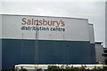
1
View of the Sainsbury's warehouse near Rye House from the Lea Valley line
Looking north-northeast.
Image: © Robert Lamb
Taken: 3 May 2015
0.06 miles
2
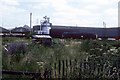
Freight train at Rye House
Shunting the wagons at Rye House Costains sidings where concrete sleepers used to be made. A daily freight service would then take them away to Temple Mills, East London. The freight service would normally arrive after eleven and shunt the sidings between the passage of the half hourly passenger service between Hertford East and Liverpool Street.
Image: © roger geach
Taken: Unknown
0.10 miles
3
View of industrial land near Rye House from the Lea Valley Line
Looking north-northeast.
Image: © Robert Lamb
Taken: 3 May 2015
0.10 miles
5
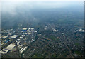
Hoddesdon from the air
Looking over the Old Highway Recreation Ground and Rye House railway station.
Image: © Thomas Nugent
Taken: 16 Mar 2016
0.13 miles
6
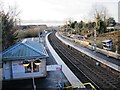
Rye House station (3)
Looking south from the bridge.
Image: © Mike Quinn
Taken: 14 Jan 2015
0.14 miles
7
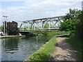
Railway bridge over the River Lea near Hoddesdon
This bridge carries the railway line linking London (Liverpool Street) with Stansted Airport and Cambridge across the River Lea (or lee) in Hertfordshire.
The towpath along the river bank is a shred path for walking and cycling.
Image: © Malc McDonald
Taken: 1 Jun 2013
0.14 miles
8
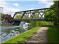
Railway bridge BGK/1436, Rye House
The main Liverpool Street - Cambridge line crosses the River Lee Navigation.
Image: © Robin Webster
Taken: 15 May 2016
0.15 miles
9
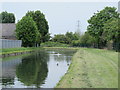
The New River southeast of Salisbury Road, EN11 (3)
See Image
Image: © Mike Quinn
Taken: 27 May 2015
0.16 miles
10
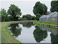
The New River east of Salisbury Road, EN11 (2)
See Image
Image: © Mike Quinn
Taken: 27 May 2015
0.16 miles