IMAGES TAKEN NEAR TO
Woodstock Road, BROXBOURNE, EN10 7PD
Introduction
This page details the photographs taken nearby to Woodstock Road, EN10 7PD by members of the Geograph project.
The Geograph project started in 2005 with the aim of publishing, organising and preserving representative images for every square kilometre of Great Britain, Ireland and the Isle of Man.

There are currently over 7.5m images from over14,400 individuals and you can help contribute to the project by visiting https://www.geograph.org.uk
Image Map (Loading...)


Getting Data...Please wait
Leaflet Map data © OpenStreetMap
Images are licensed for reuse under creativecommons.org/licenses/by-sa/2.0
Notes
- Clicking on the map will re-center to the selected point.
- The higher the marker number, the further away the image location is from the centre of the postcode.
Image Listing (6 Images Found)
Images are licensed for reuse under creativecommons.org/licenses/by-sa/2.0
Image
Details
Distance
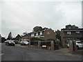
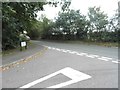
1
Cock Lane
Entering the built-up area of Hoddesdon, with the first residential road, Crabtree Walk, ahead on the right.
Image: © Robin Webster
Taken: 21 Aug 2015
0.12 miles
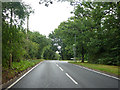
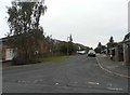
2
Cock Lane at the junction of Park Lane
Image: © David Howard
Taken: 15 Oct 2015
0.13 miles
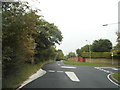
4
Harmonds Wood Close at the junction of Cock Lane
This is the first suburban road as you enter Hoddesdon from the countryside you can see opposite.
Image: © David Howard
Taken: 15 Oct 2015
0.19 miles
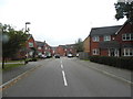
5
Sheredes Drive at the junction of Cock Lane
Image: © David Howard
Taken: 15 Oct 2015
0.23 miles