IMAGES TAKEN NEAR TO
Churchfields, BROXBOURNE, EN10 7JS
Introduction
This page details the photographs taken nearby to Churchfields, EN10 7JS by members of the Geograph project.
The Geograph project started in 2005 with the aim of publishing, organising and preserving representative images for every square kilometre of Great Britain, Ireland and the Isle of Man.

There are currently over 7.5m images from over14,400 individuals and you can help contribute to the project by visiting https://www.geograph.org.uk
Image Map
Images are licensed for reuse under creativecommons.org/licenses/by-sa/2.0
Notes
- Clicking on the map will re-center to the selected point.
- The higher the marker number, the further away the image location is from the centre of the postcode.
Image Listing (116 Images Found)
Images are licensed for reuse under creativecommons.org/licenses/by-sa/2.0
Image
Details
Distance
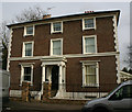
1
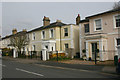
C19 villas in Churchfields, Broxbourne
This group of houses date from 1840.
Image: © David Kemp
Taken: 11 Mar 2017
0.03 miles
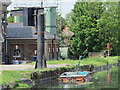
4
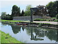
Hoist by the New River by Broxbourne Pumping Station
See Image
Image: © Mike Quinn
Taken: 27 May 2015
0.13 miles
5
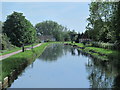
The New River by Broxbourne Pumping Station (3)
Image: © Mike Quinn
Taken: 27 May 2015
0.13 miles
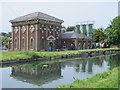
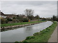
7
The New River by Broxbourne Pumping Station
See Image
Image: © Mike Quinn
Taken: 27 May 2015
0.13 miles
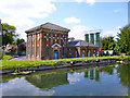
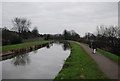
8
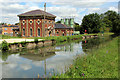
Pumping Station, New River, Broxbourne, Hertfordshire
Image: © Christine Matthews
Taken: 1 Jul 2011
0.13 miles