IMAGES TAKEN NEAR TO
Graham Avenue, BROXBOURNE, EN10 7DU
Introduction
This page details the photographs taken nearby to Graham Avenue, EN10 7DU by members of the Geograph project.
The Geograph project started in 2005 with the aim of publishing, organising and preserving representative images for every square kilometre of Great Britain, Ireland and the Isle of Man.

There are currently over 7.5m images from over14,400 individuals and you can help contribute to the project by visiting https://www.geograph.org.uk
Image Map (Loading...)


Getting Data...Please wait
Leaflet Map data © OpenStreetMap
Images are licensed for reuse under creativecommons.org/licenses/by-sa/2.0
Notes
- Clicking on the map will re-center to the selected point.
- The higher the marker number, the further away the image location is from the centre of the postcode.
Image Listing (6 Images Found)
Images are licensed for reuse under creativecommons.org/licenses/by-sa/2.0
Image
Details
Distance
2
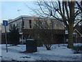
Modern house on the corner of Allard Way, Broxbourne
This was probably built in the 70s and architect designed.
Image: © David Howard
Taken: 7 Feb 2012
0.21 miles
3
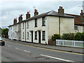
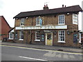
Cottages, High Road, Broxbourne
The nearest four of the seven are grade II listed buildings.
Image: © Robin Webster
Taken: 4 Sep 2015
0.23 miles
4
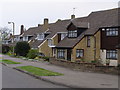
Suburban Housing Broxbourne Herts
One of many relatively new housing estates that have been built in Broxbourne to help cater for the ever growing demand for housing in the South East.
Image: © Chris Hunt
Taken: 20 Apr 2006
0.23 miles
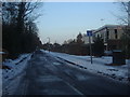
6
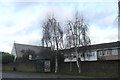
High Road, Broxbourne
Looking towards the United Reformed Church on Mill Lane
Image: © David Howard
Taken: 29 Dec 2018
0.25 miles