IMAGES TAKEN NEAR TO
Old Nazeing Road, BROXBOURNE, EN10 6RX
Introduction
This page details the photographs taken nearby to Old Nazeing Road, EN10 6RX by members of the Geograph project.
The Geograph project started in 2005 with the aim of publishing, organising and preserving representative images for every square kilometre of Great Britain, Ireland and the Isle of Man.

There are currently over 7.5m images from over14,400 individuals and you can help contribute to the project by visiting https://www.geograph.org.uk
Image Map
Images are licensed for reuse under creativecommons.org/licenses/by-sa/2.0
Notes
- Clicking on the map will re-center to the selected point.
- The higher the marker number, the further away the image location is from the centre of the postcode.
Image Listing (5 Images Found)
Images are licensed for reuse under creativecommons.org/licenses/by-sa/2.0
Image
Details
Distance
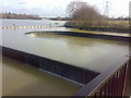
2
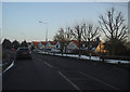
River Lee Flood Relief Channel
Viewed from the B194 Nazeing Road bridge.
Image: © Nigel Cox
Taken: 14 Jul 2006
0.05 miles
3
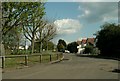
Part of Nazeing Road, just east of Broxbourne
Image: © Robert Edwards
Taken: 23 Apr 2008
0.05 miles
4
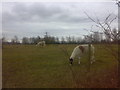
A pair of llamas grazing with sheep
Every winter these animals are allowed to graze in this field before returning to Hayes Hill farm.
Image: © Vaughan Callaghan
Taken: 17 Mar 2007
0.18 miles
5
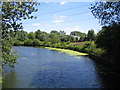
Nazeing Labyrinth Weir
Interestingly, there is an Environment Agency sign at the edge of the weir naming it and giving the National Grid reference as TQ 3830 0660.
Image: © Vaughan Callaghan
Taken: 9 Mar 2007
0.25 miles