IMAGES TAKEN NEAR TO
Old Nazeing Road, BROXBOURNE, EN10 6RN
Introduction
This page details the photographs taken nearby to Old Nazeing Road, EN10 6RN by members of the Geograph project.
The Geograph project started in 2005 with the aim of publishing, organising and preserving representative images for every square kilometre of Great Britain, Ireland and the Isle of Man.

There are currently over 7.5m images from over14,400 individuals and you can help contribute to the project by visiting https://www.geograph.org.uk
Image Map (Loading...)


Getting Data...Please wait
Leaflet Map data © OpenStreetMap
Images are licensed for reuse under creativecommons.org/licenses/by-sa/2.0
Notes
- Clicking on the map will re-center to the selected point.
- The higher the marker number, the further away the image location is from the centre of the postcode.
Image Listing (2 Images Found)
Images are licensed for reuse under creativecommons.org/licenses/by-sa/2.0
Image
Details
Distance
1
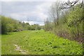
A "Ride" in Lee Valley Country park
Open rides in woodland provide scope for biodiversity.
Image: © Glyn Baker
Taken: 23 Apr 2016
0.23 miles
2
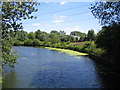
River Lee Flood Relief Channel
Viewed from the B194 Nazeing Road bridge.
Image: © Nigel Cox
Taken: 14 Jul 2006
0.23 miles