IMAGES TAKEN NEAR TO
Berners Way, BROXBOURNE, EN10 6NJ
Introduction
This page details the photographs taken nearby to Berners Way, EN10 6NJ by members of the Geograph project.
The Geograph project started in 2005 with the aim of publishing, organising and preserving representative images for every square kilometre of Great Britain, Ireland and the Isle of Man.

There are currently over 7.5m images from over14,400 individuals and you can help contribute to the project by visiting https://www.geograph.org.uk
Image Map
Images are licensed for reuse under creativecommons.org/licenses/by-sa/2.0
Notes
- Clicking on the map will re-center to the selected point.
- The higher the marker number, the further away the image location is from the centre of the postcode.
Image Listing (37 Images Found)
Images are licensed for reuse under creativecommons.org/licenses/by-sa/2.0
Image
Details
Distance
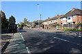
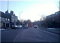
2
310 bus on High Street Wormley
Google Streetview shows one of these buses in the same stop
Image: © David Howard
Taken: 29 Dec 2018
0.12 miles
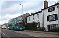
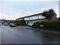
3
The Old Star Public House, Wormley, Hertfordshire
The Old Star is on Wormley High Road.
Image: © Christine Matthews
Taken: 24 Feb 2011
0.12 miles
4
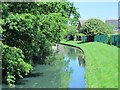
The New River by St. Laurence Drive, EN10
Image: © Mike Quinn
Taken: 27 May 2015
0.12 miles
5
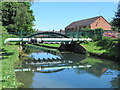
Footbridge over the New River by St. Laurence Drive, EN10
See Image
Image: © Mike Quinn
Taken: 27 May 2015
0.13 miles
6
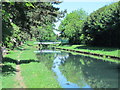
The New River by Church Lane Allotment (3)
See Image
Image: © Mike Quinn
Taken: 27 May 2015
0.13 miles
7
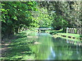
The New River by Church Lane Allotment
See Image
Image: © Mike Quinn
Taken: 27 May 2015
0.13 miles
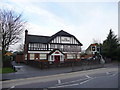
10
Lammasmead, Wormley, Hertfordshire
As seen from the junction with Wharf Road.
Image: © Christine Matthews
Taken: 24 Feb 2011
0.16 miles