IMAGES TAKEN NEAR TO
Juniper Close, BROXBOURNE, EN10 6HR
Introduction
This page details the photographs taken nearby to Juniper Close, EN10 6HR by members of the Geograph project.
The Geograph project started in 2005 with the aim of publishing, organising and preserving representative images for every square kilometre of Great Britain, Ireland and the Isle of Man.

There are currently over 7.5m images from over14,400 individuals and you can help contribute to the project by visiting https://www.geograph.org.uk
Image Map (Loading...)


Getting Data...Please wait
Leaflet Map data © OpenStreetMap
Images are licensed for reuse under creativecommons.org/licenses/by-sa/2.0
Notes
- Clicking on the map will re-center to the selected point.
- The higher the marker number, the further away the image location is from the centre of the postcode.
Image Listing (33 Images Found)
Images are licensed for reuse under creativecommons.org/licenses/by-sa/2.0
Image
Details
Distance
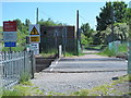
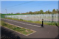
2
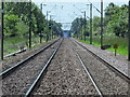
Railway tracks south of the level crossing, Slipe Lane, EN10
Image: © Mike Quinn
Taken: 27 May 2015
0.08 miles
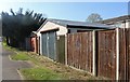
3
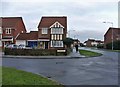
Waltham Gate, Turnford, Hertfordshire
Waltham Gate, Turnford. This housing estate was built on the site of the former Rochfords Garden Centre
Image: © Christine Matthews
Taken: 1 Jan 2006
0.08 miles
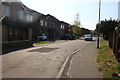
7
Slipe Lane, EN10, east of the level crossing
Image: © Mike Quinn
Taken: 27 May 2015
0.14 miles
8
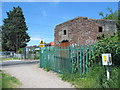
WWII pillbox by the level crossing, Slipe Lane, EN10
Image: © Mike Quinn
Taken: 27 May 2015
0.14 miles
9
Footbridge entrance in Wormley
Crossing the Cheshunt line
Image: © David Howard
Taken: 20 Apr 2019
0.14 miles
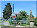
10
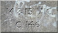
Inscription on the coal tax boundary obelisk no.21 by the level crossing, Slipe Lane, EN10
Image: © Mike Quinn
Taken: 27 May 2015
0.14 miles