IMAGES TAKEN NEAR TO
Macers Court, BROXBOURNE, EN10 6DZ
Introduction
This page details the photographs taken nearby to Macers Court, EN10 6DZ by members of the Geograph project.
The Geograph project started in 2005 with the aim of publishing, organising and preserving representative images for every square kilometre of Great Britain, Ireland and the Isle of Man.

There are currently over 7.5m images from over14,400 individuals and you can help contribute to the project by visiting https://www.geograph.org.uk
Image Map (Loading...)


Getting Data...Please wait
Leaflet Map data © OpenStreetMap
Images are licensed for reuse under creativecommons.org/licenses/by-sa/2.0
Notes
- Clicking on the map will re-center to the selected point.
- The higher the marker number, the further away the image location is from the centre of the postcode.
Image Listing (69 Images Found)
Images are licensed for reuse under creativecommons.org/licenses/by-sa/2.0
Image
Details
Distance
1

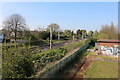
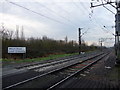
Fairfield Drive, Wormley
From the railway bridge
Image: © David Howard
Taken: 20 Apr 2019
0.05 miles
4
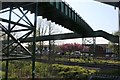
Footbridge over the railway in Wormley
Image: © David Howard
Taken: 20 Apr 2019
0.08 miles
6
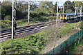
Wharf Road Level Crossing, Wormley, Hertfordshire
Looking southwards from the level crossing.
Image: © Christine Matthews
Taken: 24 Feb 2011
0.09 miles
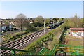
7
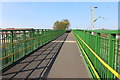
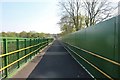
Footbridge over the railway in Wormley
It is very long and uphill all the way.
Image: © David Howard
Taken: 20 Apr 2019
0.09 miles
8
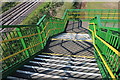
Steps from the railway bridge in Wormley
Image: © David Howard
Taken: 20 Apr 2019
0.09 miles
9
Footbridge over the railway in Wormley
Image: © David Howard
Taken: 20 Apr 2019
0.10 miles
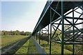
10
Footbridge over the railway in Wormley
They have chosen a very nice set of colours
Image: © David Howard
Taken: 20 Apr 2019
0.10 miles