IMAGES TAKEN NEAR TO
Priory Close, BROXBOURNE, EN10 6AB
Introduction
This page details the photographs taken nearby to Priory Close, EN10 6AB by members of the Geograph project.
The Geograph project started in 2005 with the aim of publishing, organising and preserving representative images for every square kilometre of Great Britain, Ireland and the Isle of Man.

There are currently over 7.5m images from over14,400 individuals and you can help contribute to the project by visiting https://www.geograph.org.uk
Image Map
Images are licensed for reuse under creativecommons.org/licenses/by-sa/2.0
Notes
- Clicking on the map will re-center to the selected point.
- The higher the marker number, the further away the image location is from the centre of the postcode.
Image Listing (57 Images Found)
Images are licensed for reuse under creativecommons.org/licenses/by-sa/2.0
Image
Details
Distance
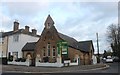
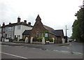
1
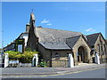
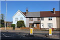
Wormley Free Church, High Road / Slipe Lane, EN10
Image: © Mike Quinn
Taken: 27 May 2015
0.05 miles
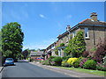
4
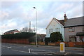
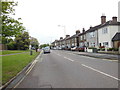
Houses on High Road, Turnford
I've been here recently https://www.geograph.org.uk/photo/6010792
Image: © David Howard
Taken: 20 Apr 2019
0.06 miles
6
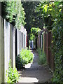
Path between the New River and High Road, Turnford, EN10
Image: © Mike Quinn
Taken: 27 May 2015
0.08 miles
9
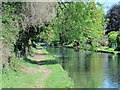
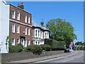
The New River west of High Road, Turnford, EN10
See Image
Image: © Mike Quinn
Taken: 27 May 2015
0.11 miles