
IMAGES TAKEN NEAR TO
Holyrood Road, EDINBURGH, EH8 8JF
Introduction
This page details the photographs taken nearby to Holyrood Road, EH8 8JF by members of the Geograph project.
The Geograph project started in 2005 with the aim of publishing, organising and preserving representative images for every square kilometre of Great Britain, Ireland and the Isle of Man.

There are currently over 7.5m images from over14,400 individuals and you can help contribute to the project by visiting https://www.geograph.org.uk
Image Map
Images are licensed for reuse under creativecommons.org/licenses/by-sa/2.0
Notes
- Clicking on the map will re-center to the selected point.
- The higher the marker number, the further away the image location is from the centre of the postcode.
Image Listing (1880 Images Found)
Images are licensed for reuse under creativecommons.org/licenses/by-sa/2.0
Image
Details
Distance
1
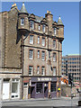
The Holyrood, 9A Holyrood Road
Public house with tenements over, in Scottish Baronial style, by R.M.Cameron. Dated 1895, it remains little altered. Listed Category C.
Image: © Alan Murray-Rust
Taken: 8 Jun 2013
0.00 miles
2

Morgan's Lane
The redevelopment of some of the Moray House site.
Image: © Richard Webb
Taken: 11 Mar 2017
0.01 miles
3

Coffee shop on corner of Holyrood Road
Image: © David Martin
Taken: 18 Jun 2013
0.01 miles
4
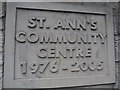
Plaque in St Mary's Street (b)
An impressive edifice for an institution which only existed for just under thirty years
Image: © Basher Eyre
Taken: 14 Aug 2014
0.01 miles
5

St. Mary's Street from the Cowgate
Formerly known as St. Mary's Wynd before Victorian street improvements in the 1870s led to its widening, rebuilding and renaming as St. Mary's Street. The wynd ran from the Cowgate Port and St. Mary's Port up to the Netherbow Port where it connected with Leith Wynd, swept away by the creation of Jeffrey Street.
Image: © kim traynor
Taken: 23 May 2012
0.01 miles
6

The Tass, High St
A fine real ale pub on the Royal Mile.
Image: © N Chadwick
Taken: 21 Feb 2011
0.01 miles
7

Travelodge, St. Mary's Street
The view through a gap in buildings on St. John's Hill shows the Travelodge on the former site of the Ben Line shipping company offices. The spire of St. Patrick's in the Cowgate rises behind.
Image: © kim traynor
Taken: 13 Aug 2013
0.02 miles
8

A city crossroads, Edinburgh
Looking from Cowgate across to Holyrood Road, with St Mary's Street left and Pleasance round to the right.
Image: © Robin Webster
Taken: 16 Sep 2019
0.02 miles
9

Victorian Scots Baronial, St Mary's Street
The Scottish building tradition of adding roof-level turrets for the defence of mediaeval tower-houses was continued by Victorian tenement builders. This building was among the first to result from the City Improvement Act of 1867. It involved widening St. Mary's Wynd, named after a 15thC hospital which stood at its head on the present site of the World's End pub. This building overlooks the site of the Cowgate Port in the old town wall.
Image: © kim traynor
Taken: 5 Jun 2009
0.02 miles
