
IMAGES TAKEN NEAR TO
Loganlea Drive, EDINBURGH, EH7 6LW
Introduction
This page details the photographs taken nearby to Loganlea Drive, EH7 6LW by members of the Geograph project.
The Geograph project started in 2005 with the aim of publishing, organising and preserving representative images for every square kilometre of Great Britain, Ireland and the Isle of Man.

There are currently over 7.5m images from over14,400 individuals and you can help contribute to the project by visiting https://www.geograph.org.uk
Image Map
Images are licensed for reuse under creativecommons.org/licenses/by-sa/2.0
Notes
- Clicking on the map will re-center to the selected point.
- The higher the marker number, the further away the image location is from the centre of the postcode.
Image Listing (118 Images Found)
Images are licensed for reuse under creativecommons.org/licenses/by-sa/2.0
Image
Details
Distance
1

Loganlea Drive
1930s housing on the site of the policies of Craigentinny House and Restalrig House.
Image: © Richard Webb
Taken: 16 Feb 2024
0.01 miles
2

Craigentinny Community Garden
The primary school is in the background.
Image: © Richard Webb
Taken: 16 Feb 2024
0.04 miles
3

Small houses, Loaning Road
An almost intact enclosure outside Craigentinny House. Mostly grass with three rows of small houses, probably sheltered housing.
Image: © Richard Webb
Taken: 16 Feb 2024
0.04 miles
4
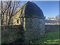
Tower, Craigentinny House
There was once a rectangular enclosure in front of the tower house, about 1ha in area. This small tower is set in the wall. The enclosure is filled with small houses, probably sheltered housing.
Image: © Richard Webb
Taken: 16 Feb 2024
0.05 miles
5

Loaning Road
This is one of four short rows of what look like sheltered housing on the south side of Loaning Road.
Image: © Anne Burgess
Taken: 9 Mar 2017
0.05 miles
6

Path, Craigentinny
Along the course of a road to Craigentinny House before the 1930s developments. The wall is a remnant of the policies. There is a primary school behind the defences on the right.
Image: © Richard Webb
Taken: 16 Feb 2024
0.06 miles
7

Craigentinny Primary School
A Friday during the mid term break. However the building is surrounded by Heras fencing and is being worked on. The school, like the surrounding housing was built in the 1930s.
Image: © Richard Webb
Taken: 16 Feb 2024
0.07 miles
8
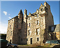
Craigentinny House
Originally a 16th century laird's house, Craigentinny has been much altered and added to. There was an east wing which was destroyed during the second world war, and a most unfortunate extension has been tacked on in its place and extending to the street and into what was the walled garden.
Image: © Anne Burgess
Taken: 9 Mar 2017
0.07 miles

10
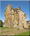
Craigentinny House
Originally a 16th century laird's house, Craigentinny has been much altered and added to. There was an east wing which was destroyed during the second world war, and a most unfortunate extension has been tacked on in its place and extending to the street and into what was the walled garden.
Image: © Anne Burgess
Taken: 9 Mar 2017
0.07 miles