
IMAGES TAKEN NEAR TO
Marionville Road, EDINBURGH, EH7 6AW
Introduction
This page details the photographs taken nearby to Marionville Road, EH7 6AW by members of the Geograph project.
The Geograph project started in 2005 with the aim of publishing, organising and preserving representative images for every square kilometre of Great Britain, Ireland and the Isle of Man.

There are currently over 7.5m images from over14,400 individuals and you can help contribute to the project by visiting https://www.geograph.org.uk
Image Map
Images are licensed for reuse under creativecommons.org/licenses/by-sa/2.0
Notes
- Clicking on the map will re-center to the selected point.
- The higher the marker number, the further away the image location is from the centre of the postcode.
Image Listing (168 Images Found)
Images are licensed for reuse under creativecommons.org/licenses/by-sa/2.0
Image
Details
Distance
1

Easter Road Deviation
A railway that sometimes carried passenger services east from Waverley - passing north of Meadowbank Stadium. Around 2000 the link with Waverley was closed and this bit of the line remained open serving the waste disposal facility at Powderhall.
Image: © Richard Webb
Taken: 12 Jan 2023
0.02 miles
2

Taoist Tai Chi
For sale, the building has been through several uses including car hire and by the looks of it, a cash and carry.
Image: © Richard Webb
Taken: 3 Feb 2020
0.03 miles
3

The Waste Railway
Once an alternative bit of the East Coast Main Line, and then a reopened spur serving the Powderhall waste processing facility, this railway is now becoming overgrown. Powderhall has gone, replaced by a new incinerator and recycling centre at Monktonhall.
Image: © Richard Webb
Taken: 3 Feb 2020
0.03 miles
4

The Powderhall branch
It was rebuilt to serve the Powderhall waste transfer facility, now demolished. The line is becoming overgrown.
Image: © Richard Webb
Taken: 3 Feb 2020
0.04 miles
5
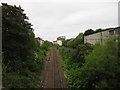
Railway passing under Marionville Road
This single track railway line passes under Marionville Road. A line of sleepers can still be distinguished on the left of the line in use indicating that the line once had 2 tracks. The disused line on the left appears to be slowly disappearing into the undergrowth however.
Image: © Graham Robson
Taken: 24 May 2014
0.05 miles
6

Meadowbank Stadium
A somewhat overgrown bit by Marionville Road.
Image: © Richard Webb
Taken: 12 Jan 2023
0.05 miles
7

Marionville Court
A nursing home beside Lochend Park.
Image: © Richard Webb
Taken: 3 Feb 2020
0.05 miles
8

Site awaiting development, Marionville Road
This building Image has now been demolished.
Image: © Richard Webb
Taken: 12 Jan 2023
0.05 miles
9

Turnstiles, Marionville Road
Meadowbank Stadium shortly before closure and demolition. The turnstiles were rarely if ever used for football matches as it was only permitted to use the main stand (on the opposite side of the stadium). The two former tenants are in Almondvale, Livingston and sharing Ainslie Park with Spartans.
Image: © Richard Webb
Taken: 12 Nov 2017
0.05 miles
10

A lone runner at Meadowbank
This is the northeast corner of Meadowbank Stadium. Rumour has it that the stadium has a short life expectancy as the "developers" are hot on its heels.
Image: © Des Colhoun
Taken: 2 Mar 2013
0.06 miles