
IMAGES TAKEN NEAR TO
Easter Road, EDINBURGH, EH7 5QE
Introduction
This page details the photographs taken nearby to Easter Road, EH7 5QE by members of the Geograph project.
The Geograph project started in 2005 with the aim of publishing, organising and preserving representative images for every square kilometre of Great Britain, Ireland and the Isle of Man.

There are currently over 7.5m images from over14,400 individuals and you can help contribute to the project by visiting https://www.geograph.org.uk
Image Map
Images are licensed for reuse under creativecommons.org/licenses/by-sa/2.0
Notes
- Clicking on the map will re-center to the selected point.
- The higher the marker number, the further away the image location is from the centre of the postcode.
Image Listing (236 Images Found)
Images are licensed for reuse under creativecommons.org/licenses/by-sa/2.0
Image
Details
Distance
1
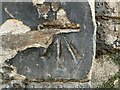
Benchmark, St. Margaret?s Church
Detail of the Ordnance Survey cut benchmark on the southwest angle of the west face of St. Margaret’s Scottish Episcopal Church on Easter Road. The benchmark marks a height of 30.1508m above mean sea level (Ordnance Datum Newlyn) last verified in 1966 (location photograph Image).
Image: © Adrian Taylor
Taken: 25 Mar 2022
0.01 miles
2
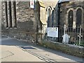
St. Margaret?s Church, Easter Road
Detail of the west face of St. Margaret’s Scottish Episcopal Church on Easter Road.
There is an eroded Ordnance Survey cut benchmark near the bottom of the wall corner adjacent to the buttress (detail photograph Image).
Image: © Adrian Taylor
Taken: 25 Mar 2022
0.01 miles


5

Sunnyside
Shows what a lot of this area was like before being developed for housing. The neighbourhood of Hibernian Football Club has changed a lot
Image: © Richard Webb
Taken: 12 Jan 2023
0.02 miles
6

Sunnyside, off Easter Road
The lane was formerly known as 172 Easter Road before the Council changed its name in 2002.
Image: © kim traynor
Taken: 22 Sep 2009
0.03 miles
7

Easter Road
The southern end of the main part of the road, which is about 1.4 km long in total, ending in the north at Leith
Image: © M J Richardson
Taken: 31 Aug 2007
0.03 miles
8

Bothwell House, Bothwell Street
The former printing works of Whyte, Andrew, & Son, Ltd have been turned into modern flats
Image: © kim traynor
Taken: 22 Sep 2009
0.03 miles
9

Bothwell Street, off Easter Road
The grey buildings are the former printing works of Whyte, Andrew, & Son, now converted into private flats.
Image: © kim traynor
Taken: 22 Sep 2009
0.03 miles
10

Easter Road crosses the railway
A view looking west from Crawford Bridge, over the site of Easter Road Station, the line that once went to Granton now terminates at the Powderhall refuse depot. A reciprocal view to Image
Image: © M J Richardson
Taken: 6 Apr 2011
0.04 miles