
IMAGES TAKEN NEAR TO
Brunswick Road, EDINBURGH, EH7 5PF
Introduction
This page details the photographs taken nearby to Brunswick Road, EH7 5PF by members of the Geograph project.
The Geograph project started in 2005 with the aim of publishing, organising and preserving representative images for every square kilometre of Great Britain, Ireland and the Isle of Man.

There are currently over 7.5m images from over14,400 individuals and you can help contribute to the project by visiting https://www.geograph.org.uk
Image Map
Images are licensed for reuse under creativecommons.org/licenses/by-sa/2.0
Notes
- Clicking on the map will re-center to the selected point.
- The higher the marker number, the further away the image location is from the centre of the postcode.
Image Listing (224 Images Found)
Images are licensed for reuse under creativecommons.org/licenses/by-sa/2.0
Image
Details
Distance
1

Abbeyhill Baptist Church, Brunswick Road
In the dark days of Austerity following the Second World War this brightly-lit chapel provided a warm welcome on cold, dark winter nights in the shape of the Friday 'Band of Hope'. Local urchins from the surrounding streets were often entertained by visiting American Baptists (preachers, choirs, bell-ringers etc) who must have been using donations from home to fund the copious quantities, for that time, of free orange juice, sticky buns, doughnuts and 'cokernut snowball' cakes that were devoured by the spectating bairns. These would often express their boredom by staging mini-riots, with unwanted buns flying through the air, that brought the proceedings to a temporary halt. That's ingratitude for you. But singing "My cup's full and running over" did seem a bit incongruous amid the post-war shortages of the time.
The Devil's nearest lair was Middleton's pub where many a faither spent much of his pay-packet on the same Friday nights. The Baptists, in keeping with their Temperance tradition, attempted to immunise the offspring against the demon drink by having them 'take the pledge', which ran something like this: "I promise with God's help to abstain from all intoxicating liquors as beverages, and to encourage others to do the same". Apart from an occasional deviation from 'the straight and narrow path' (another Baptist lesson of lifelong significance), it worked!
Image
Image: © kim traynor
Taken: 22 Sep 2009
0.03 miles
2

View towards Easter Road from the Calton Hill
The light-coloured flats, centre-left, stand on the redeveloped site of the old North British Railway Company's Goods Yard.
Image: © kim traynor
Taken: 2 Jul 2010
0.03 miles

4

Street sign, Elgin Street North
The street was originally East William Street, but renamed after one side was redeveloped in the 1970s.
Image: © kim traynor
Taken: 22 Sep 2009
0.03 miles
5

Abbeyhill Baptist Church, Brunswick Road
Image: © kim traynor
Taken: 22 Sep 2009
0.04 miles
6
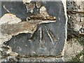
Benchmark, St. Margaret?s Church
Detail of the Ordnance Survey cut benchmark on the southwest angle of the west face of St. Margaret’s Scottish Episcopal Church on Easter Road. The benchmark marks a height of 30.1508m above mean sea level (Ordnance Datum Newlyn) last verified in 1966 (location photograph Image).
Image: © Adrian Taylor
Taken: 25 Mar 2022
0.04 miles
7
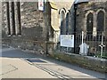
St. Margaret?s Church, Easter Road
Detail of the west face of St. Margaret’s Scottish Episcopal Church on Easter Road.
There is an eroded Ordnance Survey cut benchmark near the bottom of the wall corner adjacent to the buttress (detail photograph Image).
Image: © Adrian Taylor
Taken: 25 Mar 2022
0.04 miles
8

Easter Road
The southern end of the main part of the road, which is about 1.4 km long in total, ending in the north at Leith
Image: © M J Richardson
Taken: 31 Aug 2007
0.04 miles
9

Easter Road
Looking Leithwards on a street which is popular with start up shops.
Image: © Richard Webb
Taken: 2 Dec 2016
0.05 miles
10

Abbeyhill Baptist Church
A strangely shaped building to squeeze into.
Image: © Bill Boaden
Taken: 11 Oct 2013
0.05 miles