
IMAGES TAKEN NEAR TO
West Montgomery Place, EDINBURGH, EH7 5HA
Introduction
This page details the photographs taken nearby to West Montgomery Place, EH7 5HA by members of the Geograph project.
The Geograph project started in 2005 with the aim of publishing, organising and preserving representative images for every square kilometre of Great Britain, Ireland and the Isle of Man.

There are currently over 7.5m images from over14,400 individuals and you can help contribute to the project by visiting https://www.geograph.org.uk
Image Map
Images are licensed for reuse under creativecommons.org/licenses/by-sa/2.0
Notes
- Clicking on the map will re-center to the selected point.
- The higher the marker number, the further away the image location is from the centre of the postcode.
Image Listing (320 Images Found)
Images are licensed for reuse under creativecommons.org/licenses/by-sa/2.0
Image
Details
Distance
1

Leith Wholefood Co-op
An example of community action against poverty.
Image: © Bill Boaden
Taken: 11 Oct 2013
0.00 miles

3

New flats, Brunswick Road
Housing being built on the site of the Post Office depot.
Image: © Richard Webb
Taken: 2 Dec 2016
0.02 miles
4

Leith Walk School
The West Montgomery Street entrance.
Image: © kim traynor
Taken: 25 Aug 2011
0.02 miles

6

11-13 Brunswick Road, Edinburgh
Brunswick Road is an unusual V-shape and runs, via its big kink, roughly West to East from Leith Walk to Easter Road. Most of the buildings on the North side are new - a good proportion of these, and the cul-de-sacs that run between them, are built on land once occupied by Edinburgh's former main Royal Mail sorting office (for inbound mail) and its associated enormous parking area. Most of the buildings on the South side are far older. Almost all properties on Brunswick Road are residential.
Although the street name sounds homegrown it is actually an anglicisation of a former German state (in a very loose sense, as Germany as we know it today had not yet been invented back in the 1820s, when the road was laid) or duchy, called 'Braunschweig'. Dukes are in charge of duchies, and the street was named to honour a particular Duke of Brunswick, who died fighting for our side, leading his Brunswickers into battle against Napoleon's forces in the Battle of Quatre-Bras, which took place in 1815, two days before the far more famous battle of Waterloo. Quatre-Bras was, and still is, a hamlet in modern-day Belgium, and the name literally means 'four arms'. It is located at a crossroads, which makes perfect sense. It is interesting to note that today's French word for crossroads is 'carrefour' - proving that everyone borrows words from everybody else - see 'cul-de-sac' above. (Until tonight I just thought Carrefour was a big supermarket chain in France, that handily allows you to buy things when on holiday without having to resort to asking for a 'demi-kilo' of everything because that's all you can remember when put on the spot in smaller more traditional shops!)
The history of modern-day Germany in the early 19th Century is unbelievably complicated. Brunswick was treated as a standalone state, for instance, despite it being formed of several distinct separated areas, some of which were absolutely tiny. Most of us today are familiar with the carving up of land between the winners after the two World Wars, but exactly the same thing, in an even more complicated manner, happened after Waterloo. There were already established connections between Britain and the area at the time due to the usual tactical regal marriages and so on, but after Waterloo, the Duchy of Brunswick was officially ruled by our own Kings of the day for a decade or two in some kind of shared deal. It ultimately fell apart about 50 years on, due to Queen Victoria being a woman, reading between the lines. The Brunswickers - or whoever pulled their strings - would only allow male monarchs, and once fifth sons got involved the whole primogeniture thing was lost, and British influence gradually petered out in the following years' seemingly neverending battles and disputes.
Number 11 is the nearest to camera.
Image: © Ian Dodds
Taken: 17 May 2025
0.02 miles

8
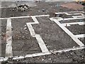
Foundations, Brunswick Road
Building on the site of the Post Office deliveries depot.
Image: © Richard Webb
Taken: 13 Mar 2016
0.03 miles

10

The Victorian Schoolroom, Leith Walk Primary School
Mmm...the pupils must be playing truant, or "skiving" as they would say.
Image: © kim traynor
Taken: 29 Sep 2013
0.03 miles