
IMAGES TAKEN NEAR TO
Anchorfield, EDINBURGH, EH6 4JG
Introduction
This page details the photographs taken nearby to Anchorfield, EH6 4JG by members of the Geograph project.
The Geograph project started in 2005 with the aim of publishing, organising and preserving representative images for every square kilometre of Great Britain, Ireland and the Isle of Man.

There are currently over 7.5m images from over14,400 individuals and you can help contribute to the project by visiting https://www.geograph.org.uk
Image Map
Images are licensed for reuse under creativecommons.org/licenses/by-sa/2.0
Notes
- Clicking on the map will re-center to the selected point.
- The higher the marker number, the further away the image location is from the centre of the postcode.
Image Listing (191 Images Found)
Images are licensed for reuse under creativecommons.org/licenses/by-sa/2.0
Image
Details
Distance


3

Tram construction works
Half of Lindsay Road is dug up for tramline construction with a one way system in operation - west bound on Lindsay Road, eastbound using Melrose Drive and Ocean Drive.
Image: © Richard Webb
Taken: 27 Mar 2021
0.01 miles
4

Hawthornvale, Newhaven
Traditional sandstone tenements viewed at the corner of Lindsay Road.
Image: © Mary and Angus Hogg
Taken: 17 Sep 2019
0.01 miles

6

New Haven Place
The A901 coastal road here between Leith and Newhaven. New apartments for the Port of Leith Housing Association are under construction.
Image: © Jim Barton
Taken: 28 Nov 2012
0.02 miles
7

Tram construction works
Half of Lindsay Road is dug up for tramline construction with a one way system in operation - west bound on Lindsay Road, eastbound using Melrose Drive and Ocean Drive.
Image: © Richard Webb
Taken: 27 Mar 2021
0.03 miles
8

Hawthornvale, Newhaven
New Year's Day 2016.
Image: © Richard Webb
Taken: 1 Jan 2016
0.03 miles
9

Lindsay Road tramline construction
Half of Lindsay Road is dug up for tramline construction with a one way system in operation - west bound on Lindsay Road, eastbound using Melrose Drive and Ocean Drive.
Image: © Richard Webb
Taken: 27 Mar 2021
0.03 miles
10
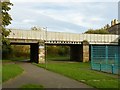
North Fort Street Bridge
This formerly carried Lindsay Road, the main road between Leith and Newhaven, across the Caledonian Railway's branch line to Leith. Lindsay Road now has a more direct alignment, and the road over the bridge has been named as an extension of the road to the right of the bridge.
Image: © Alan Murray-Rust
Taken: 12 Oct 2017
0.03 miles