
IMAGES TAKEN NEAR TO
New Lane, EDINBURGH, EH6 4JD
Introduction
This page details the photographs taken nearby to New Lane, EH6 4JD by members of the Geograph project.
The Geograph project started in 2005 with the aim of publishing, organising and preserving representative images for every square kilometre of Great Britain, Ireland and the Isle of Man.

There are currently over 7.5m images from over14,400 individuals and you can help contribute to the project by visiting https://www.geograph.org.uk
Image Map
Images are licensed for reuse under creativecommons.org/licenses/by-sa/2.0
Notes
- Clicking on the map will re-center to the selected point.
- The higher the marker number, the further away the image location is from the centre of the postcode.
Image Listing (232 Images Found)
Images are licensed for reuse under creativecommons.org/licenses/by-sa/2.0
Image
Details
Distance
1

Annfield, Newhaven
A row of houses set back from the main road through Newhaven.
Image: © Mary and Angus Hogg
Taken: 17 Sep 2019
0.02 miles
2

Anchor in Annfield Street, Newhaven
A reminder of Newhaven's days as a seaport before it was eclipsed by Granton. The street behind the anchor is Great Michael Rise which preserves the name of James IV's great flagship built in the harbour nearby.
Image: © kim traynor
Taken: 24 Jul 2011
0.03 miles
3

Anchor, Great Michael Rise
It seems likely that this anchor was put in place when the street it is at the bottom of was built in the late 1950s. Apparently it is purely ornamental and wasn't taken from a particularly relevant boat (or ship - some say that ships are just large boats, but others argue that if a boat cannot be transported on a larger boat it becomes, by definition, a ship). As Great Michael Rise was built on grassland formerly used to dry and mend nets the anchor was probably put here as a kind of elegy to a way of life that was already rapidly disappearing way back then. The street was built to rehouse the residents of New Lane - the next street to the East, rebuilt slightly later - whose properties were deemed too basic to live in at the time.
The Great Michael was the nickname given to a warship built for King James IV of Scotland at Newhaven in the early 1500s. It could also be said that it was responsible for this Edinburgh area's name: there were problems launching a slightly smaller big warship from the big port of Leith just downriver from here due to its shallower shore depths, causing King James to move his boat-building operations to this former hamlet.
The ship never got used in battle (by the Scots at least) due to its size making it too hard to handle, when it mattered, for the mariners of the day. A few years after its construction James was killed in battle and it was pragmatically (and possibly with good salesmanship) sold on to the French shortly afterwards, who may also have never risked it in battle by all accounts.
Image: © Ian Dodds
Taken: 22 Feb 2024
0.04 miles
4

The Annfield
A pub in a row of tenements, facing the Chancelot Mill.
Image: © Bill Boaden
Taken: 13 Oct 2013
0.05 miles
5

Hawthornvale, Newhaven
Seen from Hawthornvale Path, a former railway line running alongside.
Image: © Christine Johnstone
Taken: 5 Feb 2014
0.05 miles
6

New Road to Nowhere (just now)
The view of a new road and construction site in the Port of Leith Waterfront Development. A significant number of houses will be built on this site.
Image: © Sandy Gemmill
Taken: 5 Sep 2007
0.05 miles

8

Turf Zone "StreetArtZone"
Green on Great Michael Rise, Leith, Edinburgh.
Image: © Ian S
Taken: 7 Dec 2022
0.05 miles

10
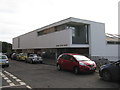
Edinburgh Sculpture Workshop
A new facility, completed in 2015, providing production, exhibition and studio spaces for artists, on Hawthornvale. For earlier stages in its construction see Image], Image
Image: © M J Richardson
Taken: 25 Sep 2016
0.06 miles