
IMAGES TAKEN NEAR TO
North Fort Street, EDINBURGH, EH6 4HB
Introduction
This page details the photographs taken nearby to North Fort Street, EH6 4HB by members of the Geograph project.
The Geograph project started in 2005 with the aim of publishing, organising and preserving representative images for every square kilometre of Great Britain, Ireland and the Isle of Man.

There are currently over 7.5m images from over14,400 individuals and you can help contribute to the project by visiting https://www.geograph.org.uk
Image Map
Images are licensed for reuse under creativecommons.org/licenses/by-sa/2.0
Notes
- Clicking on the map will re-center to the selected point.
- The higher the marker number, the further away the image location is from the centre of the postcode.
Image Listing (224 Images Found)
Images are licensed for reuse under creativecommons.org/licenses/by-sa/2.0
Image
Details
Distance
1
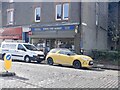
North Fort Market
Shop on North Fort Street.
Image: © Richard Webb
Taken: 27 Mar 2021
0.01 miles
2

Portland Street - North Fort Street corner
Image: © Richard Webb
Taken: 27 Mar 2021
0.02 miles

4

Madeira Street
Complete with Madeira's flag.
Image: © Richard Webb
Taken: 7 Aug 2021
0.05 miles
5

North Fort Street
With surviving walls from The Fort. Inside there was once a scheme with a certain "notoriety". It has been levelled and replaced with new houses. Feels a bit like parts of Copenhagen here now. (It is not just the Shore!)
Image: © Richard Webb
Taken: 27 Mar 2021
0.05 miles
6
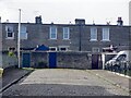
Who kept Atlantis off the maps?
The dead end of Lapicide Place. What a name for a street, at first I thought it something nasty happening to rabbits, but it means stone cutter. The houses beyond the wall are on Dudley Avenue.
(Atlantis reference - look up "Stonecutter song")
Image: © Richard Webb
Taken: 27 Mar 2021
0.06 miles
7

Baker and Confectioner
Shop undergoing renovation on Ferry Road. An old sign has been uncovered in the work.
Image: © Richard Webb
Taken: 7 Aug 2021
0.06 miles
8
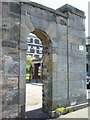
Leith Fort
One of two sentry gates that flanked the main entrance
Image: © kim traynor
Taken: 21 May 2009
0.06 miles
9
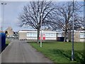
Fort Primary
Not a shopping centre, a primary school on North Fort Street, Leith. View from Lapicide Place.
Image: © Richard Webb
Taken: 27 Mar 2021
0.07 miles
10

Leith Fort Flats
Leith Fort, built in 1799, was one of Edinburgh's main Victorian military barracks. A fine Hill & Adamson photograph exists of Royal Artillery gunners posing with a cannon inside the Fort in 1846.http://en.wikipedia.org/wiki/File:Royal_Artillery_at_Leith_Fort,_1846.jpg The barracks were demolished in the 1950s and replaced with modern flats, though some original features were retained, such as the boundary wall seen here. Sadly, the housing scheme within has had more than its fair share of social problems and is slated for demolition. http://edinburghnews.scotsman.com/news/Notorious-Leith-housing-estate-set.5041228.jp But the remains of the fort, designed by the architect of Edinburgh's New Town, James Craig, to defend Leith against possible attack by the U.S. naval raider, John Paul Jones, must surely be preserved in one way or another.
Image: © kim traynor
Taken: 21 May 2009
0.07 miles