
IMAGES TAKEN NEAR TO
Woodside Terrace, WEST CALDER, EH55 8XB
Introduction
This page details the photographs taken nearby to Woodside Terrace, EH55 8XB by members of the Geograph project.
The Geograph project started in 2005 with the aim of publishing, organising and preserving representative images for every square kilometre of Great Britain, Ireland and the Isle of Man.

There are currently over 7.5m images from over14,400 individuals and you can help contribute to the project by visiting https://www.geograph.org.uk
Image Map
Images are licensed for reuse under creativecommons.org/licenses/by-sa/2.0
Notes
- Clicking on the map will re-center to the selected point.
- The higher the marker number, the further away the image location is from the centre of the postcode.
Image Listing (9 Images Found)
Images are licensed for reuse under creativecommons.org/licenses/by-sa/2.0
Image
Details
Distance
1

Tarbrax from the air
Looking northeast from over Auchengray. Tarbrax is a 'dead-end' village - only one road in, and the same one out. It is a community that owes its existence originally to the oil-shale mining industry.
Image: © M J Richardson
Taken: 11 Jul 2018
0.11 miles
2

Bowling green at Tarbrax
With a touch of frost.
Image: © M J Richardson
Taken: 19 Feb 2012
0.14 miles
3
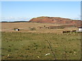
Shale bing at Tarbrax
A legacy of the 19C shale mining industry.
Image: © M J Richardson
Taken: 19 Feb 2012
0.17 miles
4

Tarbrax
Seeming marooned on the moor under its ziggurat like bing, a shale mining village long after the mines closed.
The shale mines closed around 1920.
Image: © Richard Webb
Taken: 12 Oct 2009
0.18 miles

6

Open area: Tarbrax
Tarbrax Village Hall on far side
Image: © Jim Smillie
Taken: 3 Mar 2023
0.18 miles
7

Miners' Rows: Tarbrax
Looking across open area in former shale mining village
Image: © Jim Smillie
Taken: 3 Mar 2023
0.19 miles
8

78-83 Crosswood Terrace, Tarbrax
A small group of houses in this relatively isolated village in South Lanarkshire, a remnant of the oil-shale industry.
Image: © M J Richardson
Taken: 19 Feb 2012
0.21 miles
9
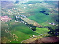
Lawhead and Tarbrax
Seen from the air on the way to Edinburgh. Tarbrax is a 'dead-end' village - only one road in, and the same one out. It is a community that owes its existence originally to the oil-shale mining industry.
Image: © M J Richardson
Taken: 18 Jun 2013
0.25 miles