
IMAGES TAKEN NEAR TO
Burnside Terrace, WEST CALDER, EH55 8NE
Introduction
This page details the photographs taken nearby to Burnside Terrace, EH55 8NE by members of the Geograph project.
The Geograph project started in 2005 with the aim of publishing, organising and preserving representative images for every square kilometre of Great Britain, Ireland and the Isle of Man.

There are currently over 7.5m images from over14,400 individuals and you can help contribute to the project by visiting https://www.geograph.org.uk
Image Map
Images are licensed for reuse under creativecommons.org/licenses/by-sa/2.0
Notes
- Clicking on the map will re-center to the selected point.
- The higher the marker number, the further away the image location is from the centre of the postcode.
Image Listing (36 Images Found)
Images are licensed for reuse under creativecommons.org/licenses/by-sa/2.0
Image
Details
Distance
1

Addiewell-Breich railway line, 2016
Taken some three years before the railway line was electrified.
Image: © Nigel Thompson
Taken: 26 Nov 2016
0.05 miles
2

Addiebrownhill from the air
The distinctive 'D' shape of Meadowhead Crescent and Meadowhead Place can be clearly seen. Part of the North British Distillers can be seen in the lower right corner.
The Skolie Burn Bridge construction site Image can be seen on the left.
Image: © Thomas Nugent
Taken: 7 Feb 2020
0.06 miles
3

Addiebrownhill from the air
The distinctive 'D' shape of Meadowhead Crescent and Meadowhead Place can be clearly seen. Part of the North British Distillers can be seen in the lower right corner.
The Skolie Burn Bridge construction site Image can be seen on the left.
Image: © Thomas Nugent
Taken: 7 Feb 2020
0.06 miles
4

Railway at Addiebrownhill
Looking west along the Edinburgh-Glasgow line via Shotts.
Image: © M J Richardson
Taken: 13 Sep 2021
0.07 miles
5

Houses, Meadowhead Loan
On a small housing estate at Addiebrownhill.
Image: © M J Richardson
Taken: 13 Sep 2021
0.13 miles
6

Recreation Park, Addiewell
Recreation Park is probably the most common name for a football ground in Britain, though this one (humourously referred to as San Siro on the sign to the far left of the goal) doesn't really qualify as a ground. The substitutes and managers are afforded some shelter by the small red-and-white dugouts, but that's about it for facilities here.
Loganlea United play here in the bottom tier of the Edinburgh and Lothians amateur leagues, though they will surely be moving up a level shortly, leaving the likes of Mental Mechanics behind, having won 15 out of 15 so far this season.
The pitch is hidden behind the houses on Mooreland Gardens - both Moorelands and Mooreland Gardens were named after Sarah 'Ma' Moore (Moorelands was named after her during her lifetime), a woman described as having a very forceful personality in her obituaries. She was a Labour councillor for Addiewell from the 1920s until her death in the 1940s. On top of this she seemed to work on every committee and board going, including some for prisons and hospitals, and was active in various campaigns, often concerning living standards. And on top of that she had nine children, and was a poet!
Image: © Ian Dodds
Taken: 9 Mar 2022
0.16 miles
7
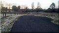
A Short Unused Road towards Meadowhead, Addiewell
There is no obvious reason why this very short road exists, or for its fine sweeping bend. It runs from Addiebrownhill Road, opposite the whisky bond entrance, to a track that leads to four properties all starting with Meadowhead. Meadowhead Cottage is the very uncottagelike building straight ahead!
The track leading to the Meadowheads used to be the route from Addiewell to what is now called the A71. And to confuse things slightly the part of Addiewell that is now referred to as Meadowhead - due to all its street names starting with Meadowhead - is on the opposite side of Addiebrownhill Road.
Image: © Ian Dodds
Taken: 17 Mar 2021
0.17 miles
8

Muirhall Whisky Bond
Operated by North British Distillers
Image: © Jim Smillie
Taken: 25 Aug 2021
0.18 miles
9

Addiewell and Loganlea Memorial Garden
Sculpture in a beautifully kept park and play area.
Image: © Richard Webb
Taken: 11 Mar 2008
0.18 miles
10
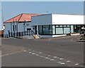
The Pit Stop
Former Miners Welfare, now a Community Hub including "The Village larder"
Image: © Jim Smillie
Taken: 25 Aug 2021
0.18 miles