
IMAGES TAKEN NEAR TO
Bramble Glade, LIVINGSTON, EH54 9JL
Introduction
This page details the photographs taken nearby to Bramble Glade, EH54 9JL by members of the Geograph project.
The Geograph project started in 2005 with the aim of publishing, organising and preserving representative images for every square kilometre of Great Britain, Ireland and the Isle of Man.

There are currently over 7.5m images from over14,400 individuals and you can help contribute to the project by visiting https://www.geograph.org.uk
Image Map
Images are licensed for reuse under creativecommons.org/licenses/by-sa/2.0
Notes
- Clicking on the map will re-center to the selected point.
- The higher the marker number, the further away the image location is from the centre of the postcode.
Image Listing (14 Images Found)
Images are licensed for reuse under creativecommons.org/licenses/by-sa/2.0
Image
Details
Distance
1

Fairly Inaccessible Pond just off Adambrae Road
Have driven past here numerous times without realising this pond existed - as can be seen it is mostly covered in vegetation. Is fed from Adambrae Burn, which has no official name on any maps, where it reappears from underneath the roundabout. Would be interesting to know the history of this burn, as looking at old maps, it once led, entirely overground, to a well slightly North of where the pond is. On later maps up until the last old map available online from the 1960s, it disappeared underground at the location the pond is now situated at, emerging further North after going underneath a slag heap, in roughly the same place the old well was situated. The pond now drains into a culvert, re-emerging past the houses, at the far corner of Bluebell Glade.
Image: © Ian Dodds
Taken: 8 Jul 2020
0.02 miles
2

Decorative roundabout at Livingston
On Adambrae Road, at its junction with Bramble and Cypress Glades, just west of Adambrae Roundabout
Image: © M J Richardson
Taken: 7 Apr 2011
0.05 miles
3

Memorable Roundabout
Given the sheer number of roundabouts in Livingston, it makes sense to decorate them with environmental art, so that people can tell where they are. This one has the twin virtues of being both eyecatching and accessible on foot!
Image: © Anne Burgess
Taken: 20 Feb 2018
0.05 miles
4

Adambrae Cemetery at Livingston
The cherry provides some spring colour, but the leaves still have to escape their buds.
Image: © M J Richardson
Taken: 7 Apr 2011
0.08 miles

6

Sundew Glade?
The culs-de-sac in this part of Livingston are all, rather incongruously, named 'Glade' with the name of a plant to distinguish them. Sundew Glade is the one behind this row of houses, but the road they front on isn't named on my map.
Image: © Anne Burgess
Taken: 20 Feb 2018
0.08 miles
7
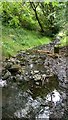
An Unexplained Stone Post in Adambrae Burn
The post is bigger than it appears in picture - 2 to 3 feet long. All old maps, which were surveyed before the construction of what we now know as Livingston, show a bridge carrying a track to Crofthead Farm at this location, so this may or may not be relevant.
In fact Adambrae is itself a bit of a mystery. The burn only gets its name as it runs through this quite well-off dead-end suburb of Livingston. Adambrae itself used to be a farm a fair distance Northeast of the suburb, just South of the River Almond, roughly where the MacArthur Glen shopping centre now is, closer to the Livingston suburbs of Howden and Dedridge. OS now muddies the waters further by showing Adambrae in two places - where the old farm once stood, and then even further South of the suburb now called Adambrae, at the East of Bellsquarry village!
Image: © Ian Dodds
Taken: 8 Jul 2020
0.12 miles
8

Path: Adambrae
Passing on the western side of the cemetery.
Image: © Jim Smillie
Taken: 12 Oct 2010
0.12 miles
9
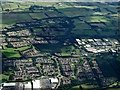
Livingston from the air
Morrison's supermarket by Adambrae roundabout at Alderstone Road at the bottom of the photo.
Image: © Thomas Nugent
Taken: 4 Aug 2013
0.16 miles
10
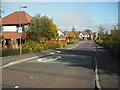
Hollyhock Glade
Part of the Adambrae development.
Image: © Jim Smillie
Taken: 12 Oct 2010
0.17 miles