
IMAGES TAKEN NEAR TO
Meikle Road, LIVINGSTON, EH54 7DE
Introduction
This page details the photographs taken nearby to Meikle Road, EH54 7DE by members of the Geograph project.
The Geograph project started in 2005 with the aim of publishing, organising and preserving representative images for every square kilometre of Great Britain, Ireland and the Isle of Man.

There are currently over 7.5m images from over14,400 individuals and you can help contribute to the project by visiting https://www.geograph.org.uk
Image Map
Images are licensed for reuse under creativecommons.org/licenses/by-sa/2.0
Notes
- Clicking on the map will re-center to the selected point.
- The higher the marker number, the further away the image location is from the centre of the postcode.
Image Listing (21 Images Found)
Images are licensed for reuse under creativecommons.org/licenses/by-sa/2.0
Image
Details
Distance
1

Livingston from the air
The town centre, on approach to Edinburgh Airport.
Image: © Thomas Nugent
Taken: 27 Nov 2016
0.04 miles
2

Garbett Road
An industrial estate in former farmland off Garbett Road.
Image: © Richard Webb
Taken: 13 Nov 2013
0.05 miles
3

Garbett Road
Leading into a 'business park'.
Image: © Jim Smillie
Taken: 8 Apr 2009
0.05 miles
4

Old milestone
July 2020, this typical Calder District Trust stone is in the Klondyke Garden Centre grounds, partially knocked over. It was found buried in a field circa 2005. It is to be reset at NT043665 at the junction of Kirkton South Road and Meikle Road. This picture does show how large these stones are and how much is usually under ground level.
Image: © John Riddell
Taken: 6 Jul 2020
0.06 miles
5

Livingston from the air
Almondvale shopping centre can be seen in the lower left corner.
Image: © Thomas Nugent
Taken: 9 Sep 2018
0.08 miles
6

Old milestone plaque
The informative plaque by the milestone taken from its recent home at the Klondyke Garden Centre and reset on Hunter Road in Livingston.
Image: © John Riddell
Taken: 30 Sep 2021
0.09 miles
7

Old milestone
This Calder District Trust milestone had been at the Klondyke Garden Centre for a number of years after being found buried in a field about 2005. At sometime it had been knocked over. Now it is back by the roadside on Hunter Road in Howden, set firmly upright with an information board nearby.
Image: © John Riddell
Taken: 30 Sep 2021
0.09 miles
8

Klondyke Garden Centre
Some of the colourful bedding plants in the open-air section of the garden centre, with black of flats in the background.
Image: © Anne Burgess
Taken: 14 Apr 2016
0.10 miles
9

Alderston Doocot
The doocot is lectern style, with 11 holes above a landing platform. It dates from the 17th century and has 803 nest boxes.
Image: © Anne Burgess
Taken: 20 Feb 2018
0.10 miles
10
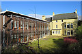
Alderston House
Originally a laird's house of the 17th century, but later altered and extended. I like the original house, and I like the modern extension. I am just not sure that I like them both quite so close together. The building is in use as corporate offices. See https://canmore.org.uk/site/49080/alderston-house.
Image: © Anne Burgess
Taken: 20 Feb 2018
0.11 miles