
IMAGES TAKEN NEAR TO
Staunton Rise, LIVINGSTON, EH54 6PB
Introduction
This page details the photographs taken nearby to Staunton Rise, EH54 6PB by members of the Geograph project.
The Geograph project started in 2005 with the aim of publishing, organising and preserving representative images for every square kilometre of Great Britain, Ireland and the Isle of Man.

There are currently over 7.5m images from over14,400 individuals and you can help contribute to the project by visiting https://www.geograph.org.uk
Image Map
Images are licensed for reuse under creativecommons.org/licenses/by-sa/2.0
Notes
- Clicking on the map will re-center to the selected point.
- The higher the marker number, the further away the image location is from the centre of the postcode.
Image Listing (15 Images Found)
Images are licensed for reuse under creativecommons.org/licenses/by-sa/2.0
Image
Details
Distance
1

Talisman Rise
Residential street in Livingston, once fields of Crofthead.
Image: © Richard Webb
Taken: 29 May 2014
0.09 miles
2

Woodland, Dedridge
Another piece of well wooded Livingston, an area of old workings now a park.
Image: © Richard Webb
Taken: 9 May 2006
0.12 miles
3

Froggy Pond, near Staunton Rise, Dedridge
Is actually officially called this on the internet-only biggest scale OS map, and has been tarted up a lot since the earlier picture in this square from 2009. A number of very tame ducks were loitering by the jetty thing while I was there. Is on the site of the former Dedridge limestone quarry. Incidentally, all the street names in this area of Livingston are, for no discernable reason, related to the novels of Walter Scott.
Image: © Ian Dodds
Taken: 25 Jul 2020
0.12 miles

5
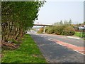
Crofthead, Livingston
Typical planned new town. Traffic and pedestrians separated with wide roads and lots of trees. Oh don't forget the roundabouts, lots of roundabouts, there is a big one with traffic lights that takes forever to get round at the bottom of this road. The tidiness of the woods and lawns is impressive.
Image: © Richard Webb
Taken: 9 May 2006
0.14 miles
6

Convenience store, Crofthead
I hope this becomes a historic supplemental. In a sprawling new town like Livingston, banks may be far from the shops and houses (the excellent Almondvale Centre is well provided for) Getting cash means using an ATM which are conveniently placed in local shops - only they charge, and heavily. OK but remember that benefits are now paid into bank accounts. Guess which income level pays the most in charges. In 2006 some machines in England were imposing a limit on the cash that could be withdrawn - that way folk pay the charges over and over again.
Image: © Richard Webb
Taken: 9 May 2006
0.14 miles
7
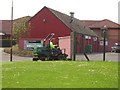
Lawnmower, Crofthead
A problem with a sprawling new town with acres of empty space, is the sheer amount of gardening required.
Image: © Richard Webb
Taken: 9 May 2006
0.16 miles
8

Staunton Rise Pond
Pond in an area of open space north of Dedridge West road.
Image: © Jim Smillie
Taken: 31 Oct 2009
0.17 miles
9
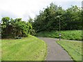
Path, Talisman Rise
The path leads to an underpass beneath the A71.
Image: © Richard Webb
Taken: 29 May 2014
0.20 miles
10

Dedridge
Typical Livvy. Concrete clad houses in a woodland setting. This part of town is well wooded and when the New Town Authority was wound up a lot of the woodland was transferred to the Woodland Trust. Behind the houses is a former shelter belt from the days when this was farmland.
Image: © Richard Webb
Taken: 9 May 2006
0.21 miles