IMAGES TAKEN NEAR TO
Afton Court, BROXBURN, EH52 6NN
Introduction
This page details the photographs taken nearby to Afton Court, EH52 6NN by members of the Geograph project.
The Geograph project started in 2005 with the aim of publishing, organising and preserving representative images for every square kilometre of Great Britain, Ireland and the Isle of Man.

There are currently over 7.5m images from over14,400 individuals and you can help contribute to the project by visiting https://www.geograph.org.uk
Image Map
Images are licensed for reuse under creativecommons.org/licenses/by-sa/2.0
Notes
- Clicking on the map will re-center to the selected point.
- The higher the marker number, the further away the image location is from the centre of the postcode.
Image Listing (21 Images Found)
Images are licensed for reuse under creativecommons.org/licenses/by-sa/2.0
Image
Details
Distance
3
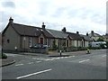
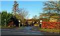
Cottages in Dechmont
Modest houses lining the north side of Main Street.
Image: © Anne Burgess
Taken: 19 Feb 2013
0.05 miles
4
Bus stop and shelter on Main Street, Dechmont
Image: © JThomas
Taken: 11 Jul 2015
0.06 miles
5
This way into Dechmont
Looking towards Knightsridge Road on the other side of the A89.
Image: © Mary and Angus Hogg
Taken: 26 Dec 2023
0.07 miles
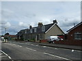
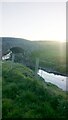
6
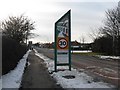
The entrance to Dechmont
This was once the A8 Edinburgh to Glasgow road, eventually by passed, and the by pass was in turn superseded by the M8, so this is now a relatively quiet 'yellow' road. The West Lothian bridge logo is a reference to the Newbridge viaduct over the River Almond - see Image and Image
Image: © M J Richardson
Taken: 3 Mar 2010
0.08 miles
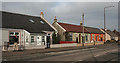
7
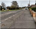
Main Street Dechmont
At junction with Burnhouse Road which is a busy route towards Linlithgow
Image: © Jim Smillie
Taken: 14 Apr 2022
0.10 miles
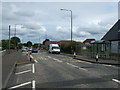
8
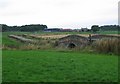
Humpbacked Bridge, Dechmont.
Busy minor road from Livingston to Linlithgow crossing the Brox Burn. A largely agricultural square, mostly grazing land.
Image: © Richard Webb
Taken: 21 Sep 2005
0.13 miles
9
Burnhouse Road Bridge, Crossing Brox Burn
This unclassified road leaves Dechmont at its Eastern end and leads to a maze of other unclassified roads crossing the countryside between here and Linlithgow, a few miles North
Image: © Ian Dodds
Taken: 21 Apr 2021
0.14 miles
10
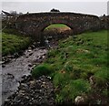
Bridge over Brox Burn
Carrying Burnhouse Road
Image: © Jim Smillie
Taken: 14 Apr 2022
0.14 miles