
IMAGES TAKEN NEAR TO
Wilson Terrace, BROXBURN, EH52 6EN
Introduction
This page details the photographs taken nearby to Wilson Terrace, EH52 6EN by members of the Geograph project.
The Geograph project started in 2005 with the aim of publishing, organising and preserving representative images for every square kilometre of Great Britain, Ireland and the Isle of Man.

There are currently over 7.5m images from over14,400 individuals and you can help contribute to the project by visiting https://www.geograph.org.uk
Image Map
Images are licensed for reuse under creativecommons.org/licenses/by-sa/2.0
Notes
- Clicking on the map will re-center to the selected point.
- The higher the marker number, the further away the image location is from the centre of the postcode.
Image Listing (33 Images Found)
Images are licensed for reuse under creativecommons.org/licenses/by-sa/2.0
Image
Details
Distance
1

Housing estate, Uphall
Housing on a sizeable estate in Uphall.
Image: © William Starkey
Taken: 8 Mar 2015
0.09 miles

3

Freeland Avenue
One of the routes into a rabbit warren of housing estates north of the main street in Uphall.
Image: © Anne Burgess
Taken: 19 Feb 2013
0.13 miles
4

Cardross Crescent, Broxburn
Houses on the western part of Cardross Crescent, view from 26 Cardross Avenue.
Image: © Jozef Wendland
Taken: 23 Apr 2003
0.14 miles
5

Broxburn: West Main Street
Local convenience store at flats on left
Image: © Jim Smillie
Taken: 1 Jun 2022
0.15 miles
6

West Main Street Broxburn
The pub on the corner is just in this square
Image: © Jim Smillie
Taken: 1 Jun 2022
0.18 miles
7

Green space off Cardross Road
Looking towards houses in Cardross Crescent, Broxburn.
Image: © Richard Webb
Taken: 14 Jan 2009
0.19 miles
8
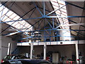
Inside a WW1 Drill Hall - 100 years on
Now being used as a car service workshop by RPM Automotive on West Main Street, Broxburn, this was the home of the 10th (Cyclist) Battalion, Royal Scots (C Company) http://www.geograph.org.uk/article/WW1-Great-War-Centenary---Drill-Halls/. The hall is the service area and the shooting gallery, behind this gable end, is used as a store. It has been with the present owner for 23 years, who bought it from the local council, and he had no idea of its previous history as a drill hall.
Image: © M J Richardson
Taken: 23 Aug 2014
0.19 miles

10

Playing Field upgrade
Fence will be taken down when goalposts are erected in July after re-seeding is established
Image: © Jim Smillie
Taken: 1 Jun 2022
0.19 miles