
IMAGES TAKEN NEAR TO
Drovers Road, BROXBURN, EH52 5ND
Introduction
This page details the photographs taken nearby to Drovers Road, EH52 5ND by members of the Geograph project.
The Geograph project started in 2005 with the aim of publishing, organising and preserving representative images for every square kilometre of Great Britain, Ireland and the Isle of Man.

There are currently over 7.5m images from over14,400 individuals and you can help contribute to the project by visiting https://www.geograph.org.uk
Image Map
Images are licensed for reuse under creativecommons.org/licenses/by-sa/2.0
Notes
- Clicking on the map will re-center to the selected point.
- The higher the marker number, the further away the image location is from the centre of the postcode.
Image Listing (15 Images Found)
Images are licensed for reuse under creativecommons.org/licenses/by-sa/2.0
Image
Details
Distance
1

Pretty deadly!
Fly agaric mushrooms growing from under a dead birch trunk. Taken in the West wood which lies near to East Mains industrial estate.
Image: © Stan Grove
Taken: 30 Sep 2006
0.15 miles
2
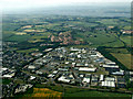
Broxburn from the air
With East Mains industrial estate in the foreground and Greendykes Bing and the River Forth in the background. The circular enclosure at West Farm http://canmore.rcahms.gov.uk/en/site/74469/details/west+farm/ can be seen to the left of the main Glasgow/Edinburgh railway line on the right side of the photo.
Image: © Thomas Nugent
Taken: 14 Jul 2013
0.15 miles
3
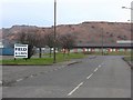
East Mains Industrial Estate
And, in the background, one of the few remaining oil-shale bings, the remains of the original Scottish oil industry, dating from the second half of the 19C.
Image: © M J Richardson
Taken: 21 Feb 2009
0.17 miles
4

The Queensferry Crossing towers
The three white towers and suspension cables, viewed from the M8 motorway, with the big blue shed of Munro & Miller Fittings Ltd dominating the scene.
Image: © Thomas Nugent
Taken: 9 Aug 2020
0.18 miles
5

Burnt out factory at East Mains Industrial Estate
Overnight in May 2009 there was a fire at this unit occupied by Campbells Meats. The building was destroyed and the company relocated elsewhere.
Image: © Calum McRoberts
Taken: 6 May 2009
0.21 miles
6
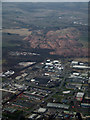
Greendykes Bing from the air
With East Mains industrial estate in the foreground.
Image: © Thomas Nugent
Taken: 3 Mar 2013
0.21 miles
7

West Lothian shale bings
A reminder of West Lothian's industrial heritage offering recreational possibilities, or an eyesore blighting the landscape? In 2005 West Lothian Council commissioned Barbra Harvie to investigate the issues, resulting in the following detailed and fascinating report. http://www.westlothian.gov.uk/media/downloaddoc/1799514/1842967/oil_shale_bings
Image: © kim traynor
Taken: 25 Jul 2012
0.22 miles
8

West Lothian shale bings
The Albyn, Greendykes and Faucheldean shale bings with the outskirts of Broxburn in the foreground and the Firth of Forth and the Ochil Hills of Fife in the distance. They're a reminder of the world's first large-scale oil industry which came to dominate the area in the 19th century, thanks to the pioneering oil extraction techniques of Glasgow-born chemist James Young, aka "Paraffin Young". Some of the bings have gradually disappeared over the past two decades as the shale has been quarried mainly for road surfacing. It was also used in the past for blaes tennis courts which have been fast disappearing in favour of all-weather surfaces. http://en.wikipedia.org/wiki/James_Young_(Scottish_chemist) http://en.wikipedia.org/wiki/Shale_oil
Image: © kim traynor
Taken: 25 Jul 2012
0.22 miles
9
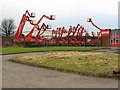
Reaching for the sky
Access equipment in waiting at the East Mains Industrial Estate.
Image: © M J Richardson
Taken: 21 Feb 2009
0.22 miles
10

Burnt out factory unit at East Mains Industrial Estate
This was the factory that was occupied by Campbells Meats until it was destroyed by fire in May 2009.
Image: © Calum McRoberts
Taken: 6 May 2009
0.22 miles