
IMAGES TAKEN NEAR TO
High Street, LINLITHGOW, EH49 7ER
Introduction
This page details the photographs taken nearby to High Street, EH49 7ER by members of the Geograph project.
The Geograph project started in 2005 with the aim of publishing, organising and preserving representative images for every square kilometre of Great Britain, Ireland and the Isle of Man.

There are currently over 7.5m images from over14,400 individuals and you can help contribute to the project by visiting https://www.geograph.org.uk
Image Map
Images are licensed for reuse under creativecommons.org/licenses/by-sa/2.0
Notes
- Clicking on the map will re-center to the selected point.
- The higher the marker number, the further away the image location is from the centre of the postcode.
Image Listing (220 Images Found)
Images are licensed for reuse under creativecommons.org/licenses/by-sa/2.0
Image
Details
Distance
1
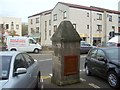
The New Well
The object in the foreground is an eighteenth-century wellhead, the New Well, located at the junction of New Well Wynd and High Street.
There would once have been several other wellheads in the High Street; their former presence is indicated by the names of streets, such as nearby Lion Well Wynd; see Image for others.
Image: © Lairich Rig
Taken: 26 Sep 2011
0.02 miles
2

New Well, High Street
Late 18th century wellhead on High Street, Linlithgow. It is Category C listed http://portal.historicenvironment.scot/designation/LB37423.
Image: © Richard Sutcliffe
Taken: 18 May 2021
0.03 miles
3

New Well, High Street
Late 18th century wellhead on High Street, Linlithgow. The wooden door is relatively recent. It is Category C listed http://portal.historicenvironment.scot/designation/LB37423.
Image: © Richard Sutcliffe
Taken: 18 May 2021
0.03 miles
4

Terraced houses at Linlithgow, West Lothian
Image: © James Denham
Taken: 21 Mar 2009
0.03 miles
5

Beinn Castle Brae, Linlithgow
The Crying of the Marches procession Image] and Image] has almost reached the west end of the High Street. Before the present St John's Avenue, in which the car is parked on the opposite side of the street, was created, there was a substantial house in the High Street known as the Beinn Castle. The rise in the High Street beside it was Beinn Castle Brae.Image] gives an excellent view up the brae.
Image: © AlastairG
Taken: 12 Jun 2009
0.04 miles
6

Linlithgow Post Office
On High Street.
Image: © Richard Sutcliffe
Taken: 18 May 2021
0.04 miles
7

Morrison's shoe shop Linlithgow
"Use it or lose it" - in this case, Linlithgow lost it. Willie Morrison's had been putting shoes on the feet of the inhabitants of Linlithgow for as long as Oliphant's Image] had been providing them with pies. At one time the Morrison family also had a tannery and boot factory on the north side of the High Street behind what is now the health centre.
Image: © AlastairG
Taken: 22 May 2009
0.05 miles
8

West Lothian Townscape : The West End Of Linlithgow High Street
Image: © Richard West
Taken: 17 Sep 2011
0.05 miles
9

The Fish Queue
Despite supermarkets and farmers markets there is still a place for a regular van selling fish out the back.
Image: © Tom Sargent
Taken: 25 Aug 2007
0.05 miles
10

Historic Linlithgow Peel
The information board (far right) says:
"Linlithgow Peel is a Royal Park. It was originally defended by a wooden palisade or 'Pele', which gave the area its distinctive name. The grounds and Loch were once used for training troops and providing food".
Image: © Barbara Carr
Taken: 3 Aug 2010
0.05 miles