
IMAGES TAKEN NEAR TO
Carlyle Terrace, BATHGATE, EH48 1BX
Introduction
This page details the photographs taken nearby to Carlyle Terrace, EH48 1BX by members of the Geograph project.
The Geograph project started in 2005 with the aim of publishing, organising and preserving representative images for every square kilometre of Great Britain, Ireland and the Isle of Man.

There are currently over 7.5m images from over14,400 individuals and you can help contribute to the project by visiting https://www.geograph.org.uk
Image Map
Images are licensed for reuse under creativecommons.org/licenses/by-sa/2.0
Notes
- Clicking on the map will re-center to the selected point.
- The higher the marker number, the further away the image location is from the centre of the postcode.
Image Listing (8 Images Found)
Images are licensed for reuse under creativecommons.org/licenses/by-sa/2.0
Image
Details
Distance
1

Shop, Kirk Road.
Bathgate street scene, looking west towards the centre.
Image: © Richard Webb
Taken: 16 Jan 2006
0.08 miles
2

Apartments on Edinburgh Road (A89), Bathgate
Image: © JThomas
Taken: 11 Jul 2015
0.17 miles
3

Bus stop and shelter on Edinburgh Road (A89)
Image: © JThomas
Taken: 11 Jul 2015
0.17 miles
4

An Overgrown Old Road, Bathgate
This mysterious old road once went the short distance from Edinburgh Road to the other side of the railway line via a bridge, then petered out. The white house ahead sits on the far side of Edinburgh Road and the now demolished bridge is behind camera.
It appears on the first OS map of the 1850s, when both sides of the railway were farmland, so presumably it was there to allow the farmer(s) to move livestock across the railway. The current bridge buttresses look more modern though, which in itself isn't that unusual. However, since the road never really appears to have gone anywhere in particular, it seems a little odd that upgrades were made. In the 1890s the road is merely shown as a bridge, joining up with nothing on either side, and in the 1940s - its possible heyday - once South of the railway it turned into a track leading to sand pits.
Image: © Ian Dodds
Taken: 6 Aug 2021
0.19 miles
5

Holediggery, Edinburgh Road
Roadworks in Bathgate.
Image: © Richard Webb
Taken: 24 Apr 2014
0.21 miles
6

Shunting operations in the marshalling yard at Bathgate
View NW, towards Bathgate (Upper), Airdrie and Glasgow; ex-North British Edinburgh - Bathgate - Glasgow line (closed to passengers 1956, reopened throughout in 2010). The locomotive shunting is ex-NB N15 0-6-2T No. 69156, with plenty of traffic in the Yard.
Image: © Ben Brooksbank
Taken: 27 Sep 1957
0.21 miles
7

Where's Rocket?
This contractor's sign at Bathgate's new railway station always makes me smile. In this case, the "bam" is the new Bathgate - Airdrie Mainline.
Image: © Richard Webb
Taken: 9 Mar 2011
0.23 miles
8
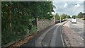
Last in a Series Of Short Fancy Walls
I didn't count them, but I reckon there are six or seven of these short walls on the Edinburgh Road in Bathgate leading towards the town centre from the Guildiehaugh (or Tesco as it is now more usually called) Roundabout. They all have an identical form, though probably vary in length a bit from section to section - the walls are just over five feet high and are always flanked by posts with ball finials which go a couple of feet higher.
Hopefully one day there will be a wall website to clear up these mysteries but at present, sadly, us wall-spotters have nowhere to go! Usually, walls like this mark the boundary of an old estate or something similar, but that seems highly unlikely in this case. The ground behind the wall descends steeply to the railway line. I mention this because of the gaps between the wall sections - not one of the gaps, as is often the case, could possibly have been there to provide access to anywhere. Furthermore, even if the ground was flat, the gaps are so regular that even then there could never have been a need for so many points of access.
Each wall section is joined by a slightly concave stretch of metal railings. They could be there because the wall fell down, but then again, if that was the case, would it not have been cheaper just to replace the wall as opposed to erecting fancy posts at each end of the surviving walls?
Back then though, sometimes price wasn't a problem - life was tougher, but people expected things to look nicer, if it came from their taxes. In contrast the recent electrification of the railway lines has led to hundreds of ugly identikit concrete bridges everywhere round here, an architectural disaster in my book.
The wall is still a mystery though - before the railway came it was mainly farmland round here.
Image: © Ian Dodds
Taken: 6 Aug 2021
0.24 miles