
IMAGES TAKEN NEAR TO
Meadow Crescent, BATHGATE, EH47 9AX
Introduction
This page details the photographs taken nearby to Meadow Crescent, EH47 9AX by members of the Geograph project.
The Geograph project started in 2005 with the aim of publishing, organising and preserving representative images for every square kilometre of Great Britain, Ireland and the Isle of Man.

There are currently over 7.5m images from over14,400 individuals and you can help contribute to the project by visiting https://www.geograph.org.uk
Image Map
Images are licensed for reuse under creativecommons.org/licenses/by-sa/2.0
Notes
- Clicking on the map will re-center to the selected point.
- The higher the marker number, the further away the image location is from the centre of the postcode.
Image Listing (34 Images Found)
Images are licensed for reuse under creativecommons.org/licenses/by-sa/2.0
Image
Details
Distance
1

Cottages: Bridge Street
Probably date from the late 19th century
Image: © Jim Smillie
Taken: 9 Jul 2021
0.06 miles
2

Fauldhouse & Crofthead railway station (site), Lothian
Opened as 'Crofthead' in 1845 by the Wilsontown, Morningside & Coltness Railway on the line that eventually ran to Bathgate, the station opened and closed sporadically over the years, closing finally to passengers in 1930. From 1906 to 1930 it was known as Fauldhouse & Crofthead.
View north east towards Longridge and Bathgate. The line ran to the right of the conifers with the single short platform being roughly where the conifers are, with sidings to the left. No trace apparently remains.
Image: © Nigel Thompson
Taken: 26 Nov 2016
0.10 miles
3

Fauldhouse War Memorial
Remembering those who died in both World Wars.
Image: © M J Richardson
Taken: 23 Aug 2014
0.13 miles

5
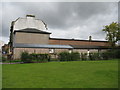
Drill hall, Fauldhouse
On Bridge Street, Fauldhouse, this was the home of the 10th (Cyclist) Battalion, Royal Scots (F Company) http://www.geograph.org.uk/article/WW1-Great-War-Centenary---Drill-Halls/. It was built in 1911 and is now part of the Fauldhouse Miners and Welfare Club, in the adjacent Baillie Institute built in 1908, originally as a community facility. The hall was burnt down about 30 years ago, and has been replaced by a modern flat-roofed building [to the right]. The shooting range [the long low building in front] has become a Chinese take away.
Image: © M J Richardson
Taken: 23 Aug 2014
0.14 miles
6
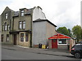
WW1 Drill Hall, Fauldhouse
On Bridge Street, Fauldhouse, this was the home of the 10th (Cyclist) Battalion, Royal Scots (F Company) http://www.geograph.org.uk/article/WW1-Great-War-Centenary---Drill-Halls/. It was built in 1911 and is now part of the Fauldhouse Miners and Welfare Club, in the adjacent Baillie Institute built in 1908, originally as a community facility. The hall was burnt down about 30 years ago, and has been replaced by a modern flat-roofed building. The shooting range has become a Chinese take away.
Image: © M J Richardson
Taken: 23 Aug 2014
0.15 miles
7
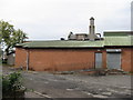
Rear of an old drill hall at Blackfaulds Place
On Bridge Street, Fauldhouse, this was the home of the 10th (Cyclist) Battalion, Royal Scots (F Company) http://www.geograph.org.uk/article/WW1-Great-War-Centenary---Drill-Halls/. The hall was burnt down about 30 years ago, and has been replaced by a modern red brick, flat-roofed building. The shooting range still exists and houses a hairdressers, just in sight on the left, and at the other end a Chinese take away.
Image: © M J Richardson
Taken: 23 Aug 2014
0.15 miles
8

Masonic Lodge, Fauldhouse
Lodge St John [No. 374], on Bridge Street.
Image: © M J Richardson
Taken: 23 Aug 2014
0.15 miles

10

Fauldhouse Miners & Welfare Club
On Bridge Street, in what was originally the Baillie Institute, a social and welfare institute built in 1908.
Image: © M J Richardson
Taken: 23 Aug 2014
0.15 miles