
IMAGES TAKEN NEAR TO
Baillie Street, BATHGATE, EH47 0EP
Introduction
This page details the photographs taken nearby to Baillie Street, EH47 0EP by members of the Geograph project.
The Geograph project started in 2005 with the aim of publishing, organising and preserving representative images for every square kilometre of Great Britain, Ireland and the Isle of Man.

There are currently over 7.5m images from over14,400 individuals and you can help contribute to the project by visiting https://www.geograph.org.uk
Image Map
Images are licensed for reuse under creativecommons.org/licenses/by-sa/2.0
Notes
- Clicking on the map will re-center to the selected point.
- The higher the marker number, the further away the image location is from the centre of the postcode.
Image Listing (10 Images Found)
Images are licensed for reuse under creativecommons.org/licenses/by-sa/2.0
Image
Details
Distance
1

King George V Playing Fields, Whitburn
King George V Playing Fields in memorial to King George V, the street on the Right is Baille Street, named after the Baille's Of Polkemmet who owned Polkemmet House.
Image: © Andrew MacKinnon
Taken: 14 Mar 2009
0.12 miles
2

Whitburn bowling green
The season should start within the next month.
Image: © Jim Smillie
Taken: 30 Mar 2009
0.15 miles
3

Whitburn Miner's Welfare
West Main Street, Whitburn.
--
Update, June 2011
The Miner's Welfare building, a former cinema suffered a minor fire in 1985 and was totally destroyed by another more serious fire on 27th June 2011. Sadly, all that's left is the front facade. (many thanks to Andrew MacKinnon for the update)
Image: © Richard Webb
Taken: 13 Jun 2008
0.15 miles
4

Whitburn Town Centre
Whitburn Town Centre viewed from former Cowhill Farm. Looking East.
Image: © Andrew MacKinnon
Taken: 29 May 2009
0.16 miles

6

Whitburn, West Lothian
Looking East towards the Town Centre.
Image: © Kevin Rae
Taken: 29 Apr 2006
0.18 miles
7

Murraysgate: this way
Industrial estate on north side of Whitburn.
Image: © Jim Smillie
Taken: 30 Mar 2009
0.21 miles
8

King George V Playing Fields, Whitburn
The playing fields were opened in 1955 by Queen Elizabeth II, in a memorial to King George V. There are 471 other playing fields that are part of the memorial. There was a cinder running track on the lower level with a football pitch in the middle, but is now one large piece or grass. The cinder track was never properly maintained and due to the fact it was below the water table, was very muddy, and still is when the local youth football teams use the pitches. The upper level has two football pitches and is also used for the galaday sports and marching arena during the fourth Saturday of June. More info at http://www.runtrackdir.com/details.asp?track=whitburn
Image: © Andrew MacKinnon
Taken: 14 Mar 2009
0.23 miles
9
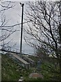
Traffic Monitoring Camera, M8 - Whitburn West
If you go to the Traffic Scotland website you can view the M8 motorway at 34 locations - this averages out at about one every two miles. This one is named Whitburn West and the images update every five minutes or so, though there's not much to see when it's dark as this section has no streetlights. I'd rather hoped some night-time technology was utilised so you could see more than the occasional vehicle light, but presumably in winter rush-hour there are so many lights it is obvious the traffic is slow.
I also wondered why they don't just put all the cameras on bridges to save money but there are a number of possible reasons I suppose - ease of maintenance, better vantage points, and ease of laying cables. Online searches, unsurprisingly, just come up with umpteen sites advising motorists on how to spot speed cameras though!
Image: © Ian Dodds
Taken: 2 May 2021
0.24 miles
10

Service station on Armadale Road, Whitburn
Image: © JThomas
Taken: 16 Sep 2021
0.25 miles