
IMAGES TAKEN NEAR TO
Brae Park, EDINBURGH, EH4 6DJ
Introduction
This page details the photographs taken nearby to Brae Park, EH4 6DJ by members of the Geograph project.
The Geograph project started in 2005 with the aim of publishing, organising and preserving representative images for every square kilometre of Great Britain, Ireland and the Isle of Man.

There are currently over 7.5m images from over14,400 individuals and you can help contribute to the project by visiting https://www.geograph.org.uk
Image Map
Images are licensed for reuse under creativecommons.org/licenses/by-sa/2.0
Notes
- Clicking on the map will re-center to the selected point.
- The higher the marker number, the further away the image location is from the centre of the postcode.
Image Listing (102 Images Found)
Images are licensed for reuse under creativecommons.org/licenses/by-sa/2.0
Image
Details
Distance
1

Houses on Brae Park Road Cramond
The road carries both the National Cycle Network route 76 (see sign - Round the Forth route) and the John Muir Way long distance walking and cycle routes.
Image: © Oliver Dixon
Taken: 1 May 2019
0.03 miles
2

Brae Park Road
The old road from Edinburgh to Queensferry which crosses the Almond by the Cramond Old Bridge.
Image: © Richard Webb
Taken: 9 Mar 2020
0.04 miles
3
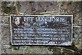
Plaque for Pet Marjorie
Marjory Fleming lived in Edinburgh between the ages of 6 and 8, being taught by her cousin. She died later, probably of meningitis. Her diaries were discovered and published 50 years after her death and became very popular during the mid-19th century onwards - see http://en.wikipedia.org/wiki/Marjorie_Fleming for details. 'Bubblyjocks' are turkey cocks (The Concise Scots Dictionary, ed. Mairi Robinson, Aberdeen U Press)
The plaque is in Brae Park Road.
Image: © Jim Barton
Taken: 28 Nov 2012
0.04 miles
4

Plaque to Pet Marjorie
On Brae Park Road. The plaque ten years ago. https://www.geograph.org.uk/photo/3243280
Image: © Ian S
Taken: 22 Mar 2022
0.04 miles
5

Plaque to Pet Marjorie
On Brae Park Road. The plaque ten years ago. https://www.geograph.org.uk/photo/3243280
Image: © Ian S
Taken: 22 Mar 2022
0.04 miles
6

Brae Park Road
Brae Park Road leading downhill at the junction with Brae Park. Both roads are cul-de-sacs although Brae Park Road lies on NCN 1 and it is possible to cycle or walk beyond the end of the road.
Image: © Callum Black
Taken: 16 Dec 2007
0.06 miles


