
IMAGES TAKEN NEAR TO
Quality Street, EDINBURGH, EH4 5BX
Introduction
This page details the photographs taken nearby to Quality Street, EH4 5BX by members of the Geograph project.
The Geograph project started in 2005 with the aim of publishing, organising and preserving representative images for every square kilometre of Great Britain, Ireland and the Isle of Man.

There are currently over 7.5m images from over14,400 individuals and you can help contribute to the project by visiting https://www.geograph.org.uk
Image Map
Images are licensed for reuse under creativecommons.org/licenses/by-sa/2.0
Notes
- Clicking on the map will re-center to the selected point.
- The higher the marker number, the further away the image location is from the centre of the postcode.
Image Listing (71 Images Found)
Images are licensed for reuse under creativecommons.org/licenses/by-sa/2.0
Image
Details
Distance
1

Well Tower
This curious round structure stands on the pavement at Davidson's Mains, just outside the gateway to East Barnton Gardens. According to Historic Scotland it is a category B listed building. It is a well tower and was used as storage for water which came from a spring on Corstorphine Hill during the 18th and 19th centuries. It was used by the people of "Muttonhole" and probably also by the residents in Lauriston Castle and the later village of Davidson's Mains. The whole area was owned by the proprietors of Barnton House.
Thanks to Dave Clark, Mike Richardson and Eunice Smith for help with the description.
Image: © Anne Burgess
Taken: 3 Apr 2011
0.01 miles
2

Charity shop, west end of Main Street
For the Chest Heart & Stroke Scotland charity. 'What's raised in Scotland stays in Scotland'.
Image: © Christine Johnstone
Taken: 5 Feb 2014
0.01 miles
3

Church of the Holy Cross
This cruciform church is a Category B listed building. It belongs to the Scottish Episcopal Church, which is the Anglican denomination in Scotland. It was designed in 1908 by John More Dick Peddie and built in 1910-12 to replace a very short-lived earlier church by George Henderson, built in 1898 and demolished in 1911.
Image: © Anne Burgess
Taken: 3 Apr 2011
0.01 miles
4

Davidson's Mains
From the grounds of the Church of the Holy Cross, the main road junction at Davidson's Mains takes on an almost village aspect.
Image: © Anne Burgess
Taken: 3 Apr 2011
0.02 miles
5
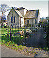
Church of the Holy Cross
This cruciform church is a category B listed building. It belongs to the Scottish Episcopal Church, which is the Anglican denomination in Scotland. It was designed in 1908 by John More Dick Peddie and built in 1910-12 to replace a very short-lived earlier church by George Henderson, built in 1898 and demolished in 1911. The church is reached from East Barnton Gardens by this attractive but rather dilapidated wrought iron gate.
Image: © Anne Burgess
Taken: 3 Apr 2011
0.02 miles
7

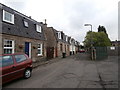
Davidson's Mains
The end of East Barnton Gardens is flanked by a pair of round pillars. This is looking between the pillars to the mini-roundabout at the end of Main Street in Davidson's Mains. The route between the pillars (the original Queensferry Road) is the original turnpike road from Edinburgh to the crossing of the River Forth. The road was moved in the 1820s and the large wall which encompasses what was then the Barnton estate of the Ramsay family was built, going right around and down to Cramond area.
Thanks to Mike Richardson and Eunice Smith for help with the description.
Image: © Anne Burgess
Taken: 3 Apr 2011
0.02 miles
8

Davidson's Mains, Edinburgh
Junction of Quality Street and Main Street.
Image: © Mike Pennington
Taken: 10 Jun 2013
0.02 miles
9

Church of the Holy Cross, Davidson's Mains
And stone lock-up?
Image: © John Lord
Taken: 5 Jun 2014
0.02 miles
10

Townhouses
New townhouses on the site of a former Shell petrol station.
Image: © Peter May
Taken: 4 Apr 2008
0.03 miles