
IMAGES TAKEN NEAR TO
Kingsmeadows Road, PEEBLES, EH45 9EN
Introduction
This page details the photographs taken nearby to Kingsmeadows Road, EH45 9EN by members of the Geograph project.
The Geograph project started in 2005 with the aim of publishing, organising and preserving representative images for every square kilometre of Great Britain, Ireland and the Isle of Man.

There are currently over 7.5m images from over14,400 individuals and you can help contribute to the project by visiting https://www.geograph.org.uk
Image Map
Images are licensed for reuse under creativecommons.org/licenses/by-sa/2.0
Notes
- Clicking on the map will re-center to the selected point.
- The higher the marker number, the further away the image location is from the centre of the postcode.
Image Listing (1024 Images Found)
Images are licensed for reuse under creativecommons.org/licenses/by-sa/2.0
Image
Details
Distance
1
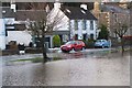
Flooding at Kingsmeadows, Peebles (2)
A short stretch of Kingsmeadows Road after 36 hours of rain which has brought flooding to the Scottish Borders and Cumbria. Kingsmeadows car park is in the foreground.
Image: © Jim Barton
Taken: 6 Dec 2015
0.01 miles
2

Kingsmeadows Road, Peebles
The road continues beyond the town as the B7063, following the Tweed valley eastwards to Traquair. Kingsmeadows Car Park is to the right. The yellow sign in the foreground to the Kingsmeadow housing development should in fact face the oncoming traffic.
Image: © Jim Barton
Taken: 29 Nov 2012
0.02 miles
3
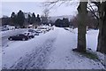
Railway trackbed, Ninian's Haugh
The track that once occupied the embankment, which now functions as a flood defence, linked the North British's Peebles Railway with the Caledonian Railway's Symington, Biggar and Broughton Railway.
Image: © Richard Webb
Taken: 20 Jan 2018
0.03 miles
4

View from the Bridge in Peebles
View across the green and river from the river bridge
Image: © Brian Joyce
Taken: 5 Mar 2005
0.03 miles
5

Temporarily restricted parking, Kingsmeadows Peebles
The fire at Peebles High School on 28th November has had several knock-on effects. Teaching has temporarily been reorganised to take place in local halls and in premises in Galashiels, as the school is closed at least until after Christmas. Kingsmeadows car park has been designated as a bus park during school hours Monday to Friday.
See also Image and Image
Image: © Jim Barton
Taken: 11 Dec 2019
0.03 miles
6

Don't try this at home
A workman trimming tree branches near the Tweed at Kingsmeadows car park. He is about 7m off the ground using a one-handed chain saw.
Image: © Jim Barton
Taken: 29 Feb 2012
0.03 miles
7

South Peebles from Ven Law (2)
Kingsmeadows car park is near the bottom of the photograph with the River Tweed out of sight below the grassy bank. Edderston farm is above centre.
Image: © Jim Barton
Taken: 27 Oct 2012
0.04 miles
8

Around Peebles (4)
Across the river from Tweed Green to King's Meadows
Image: © Anthony O'Neil
Taken: 5 Sep 2022
0.04 miles
9

Flooded children's play area, Peebles
The Tweed, swollen from the heavy rain of 19th November, has spilled over its south bank here but has been confined by the embankment of the old railway.
Image: © Jim Barton
Taken: 20 Nov 2009
0.04 miles
10

The swollen River Tweed, Peebles
Taken from the Tweed Bridge, showing the river surging through and spilling out to the low-lying land on the S side. The high ground of the Tweed's catchment to the SW will have collected plenty of rain during the 19th November.
Image: © Jim Barton
Taken: 20 Nov 2009
0.04 miles