
IMAGES TAKEN NEAR TO
Greendale Park, EDINBURGH, EH4 4QD
Introduction
This page details the photographs taken nearby to Greendale Park, EH4 4QD by members of the Geograph project.
The Geograph project started in 2005 with the aim of publishing, organising and preserving representative images for every square kilometre of Great Britain, Ireland and the Isle of Man.

There are currently over 7.5m images from over14,400 individuals and you can help contribute to the project by visiting https://www.geograph.org.uk
Image Map
Images are licensed for reuse under creativecommons.org/licenses/by-sa/2.0
Notes
- Clicking on the map will re-center to the selected point.
- The higher the marker number, the further away the image location is from the centre of the postcode.
Image Listing (19 Images Found)
Images are licensed for reuse under creativecommons.org/licenses/by-sa/2.0
Image
Details
Distance
1

Junction of Muirhouse Green and Muirhouse Park
There are 15 roads round here called Muirhouse something.
Image: © Christine Johnstone
Taken: 18 Jan 2011
0.06 miles
2

Green Space in Muirhouse
It looks as if this area has been recently mown after growing rather out of control.
Image: © Anne Burgess
Taken: 29 Mar 2012
0.08 miles

4

Muirhouse
Modern houses and flats in a cul-de-sac off Muirhouse Drive.
Image: © Anne Burgess
Taken: 29 Mar 2012
0.12 miles
5

Muirhouse St Andrew's Parish Church
The Church of Scotland parish kirk serving Muirhouse. It would look a lot better without the non-matching concrete blocks to the left.
Image: © Anne Burgess
Taken: 29 Mar 2012
0.12 miles
6

Muirhouse St Andrew's Church
Muirhouse St Andrew's church in Pennywell Gardens.
Image: © Sandy Gemmill
Taken: 30 Aug 2006
0.14 miles
7

Muirhouse Way from Muirhouse Park
Demolition has opened up a green space.
Image: © Christine Johnstone
Taken: 18 Jan 2011
0.14 miles
8

Pennywell Grove
A short street of slightly odd-shaped houses, saved from monotony by the personalisation of the second one.
Image: © Anne Burgess
Taken: 29 Mar 2012
0.15 miles
9
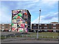
Demolition site, Muirhouse Crescent
This is the only building left on a large cleared site both sides of Muirhouse Crescent. In March 2009 demolition began at Muirhouse Way, and blocks of flats at Muirhouse Avenue, Crescent and Loan have since come down. They will be replaced by a mixed development of homes for sale and for rent.
Image: © Christine Johnstone
Taken: 18 Jan 2011
0.16 miles
10

Muirhouse Flats
High-rise and relatively low-rise council flats at Muirhouse.
Image: © Anne Burgess
Taken: 29 Mar 2012
0.16 miles