
IMAGES TAKEN NEAR TO
Letham Road, DUNBAR, EH42 1AL
Introduction
This page details the photographs taken nearby to Letham Road, EH42 1AL by members of the Geograph project.
The Geograph project started in 2005 with the aim of publishing, organising and preserving representative images for every square kilometre of Great Britain, Ireland and the Isle of Man.

There are currently over 7.5m images from over14,400 individuals and you can help contribute to the project by visiting https://www.geograph.org.uk
Image Map
Images are licensed for reuse under creativecommons.org/licenses/by-sa/2.0
Notes
- Clicking on the map will re-center to the selected point.
- The higher the marker number, the further away the image location is from the centre of the postcode.
Image Listing (359 Images Found)
Images are licensed for reuse under creativecommons.org/licenses/by-sa/2.0
Image
Details
Distance
1

Bus stop and shelter on Belhaven Road
Looking east.
Image: © JThomas
Taken: 15 May 2015
0.06 miles
2

Fabulous Flower Bed in Dunbar
Eye catching and immaculately planted as always, the message this year is THANKYOU. Castellau House in the background was used as the former library. Every year there is a wonderful flower bed planted here.
Image: © Jennifer Petrie
Taken: 10 Jul 2020
0.08 miles

4

Picnic area
The view of the picnic area at the rear of The Garden Path Cafe.
Image: © Sandy Gemmill
Taken: 23 May 2008
0.08 miles
5

THANK YOU Flower Bed in Dunbar
This flower bed is always so beautifully planted. In the background is Castellau House which was formerly used as Dunbar library.
Image: © Jennifer Petrie
Taken: 10 Jul 2020
0.08 miles


10
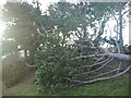
Dunbar Townscape : Storm Damage at Parsonspool - Letham Park, Dunbar
On Friday 26th November 2021 a deep depression, named Storm Arwen, moved southwards down the North Sea bringing northerly winds of severe storm strength to the east coast of the northern UK from Aberdeen to Newcastle.
In Dunbar, the wind started really blowing at around 3pm. By 6pm Dunbar was getting blasted by storm force winds. Surprisingly, although the winds were wet and full of salt spray, there was, thankfully, an absence of the heavy rain usually associated with cyclonic storms.
The storm lasted most of the night but by daybreak on Saturday morning the sky had cleared and the winds had eased off.
A morning walk down to Winterfield mains at Belhaven and then eastwards into town showed surprisingly little damage, bearing in mind the severity of the storm. There were some fragments of broken slates on the pavements in the harbour, East Shore and High Street areas of the town. The High Street was closed to vehicles because of the fragments of fallen chimney pots in the street.
It was only when walking home via the Parsonspool to Letham Park footpath that I came across the blown over Scots pine trees shown here. The nearby houses appear to have escaped damage because the wind was coming from the north rather than the west or east.
Image: © Richard West
Taken: 27 Nov 2021
0.10 miles