
IMAGES TAKEN NEAR TO
Spittal Street, EDINBURGH, EH3 9DY
Introduction
This page details the photographs taken nearby to Spittal Street, EH3 9DY by members of the Geograph project.
The Geograph project started in 2005 with the aim of publishing, organising and preserving representative images for every square kilometre of Great Britain, Ireland and the Isle of Man.

There are currently over 7.5m images from over14,400 individuals and you can help contribute to the project by visiting https://www.geograph.org.uk
Image Map
Images are licensed for reuse under creativecommons.org/licenses/by-sa/2.0
Notes
- Clicking on the map will re-center to the selected point.
- The higher the marker number, the further away the image location is from the centre of the postcode.
Image Listing (1385 Images Found)
Images are licensed for reuse under creativecommons.org/licenses/by-sa/2.0
Image
Details
Distance
1

West Port at junction with Lady Lawson Street
Image: © Robin Sones
Taken: 23 Mar 2008
0.01 miles

3

Spittal Street
From the junction with Grindlay Street.
Image: © Richard Webb
Taken: 4 Dec 2016
0.02 miles
4

Locksmith's shelves
Shelves inside Duncan McLaren, the Locksmith's shop in Bread Street.
Image: © kim traynor
Taken: 25 May 2009
0.03 miles
5

Locksmith's shop, Bread Street
The day of the Drysalter and the Ironmonger have long gone, but it seems that the Locksmith's services are as much in demand to day as ever. This is the oldest Locksmith's shop in Edinburgh, established in 1851. It has had several owners in its time, but has retained the original name.
Image: © kim traynor
Taken: 25 May 2009
0.03 miles
6
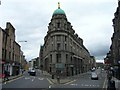
St Cuthbert's Building from Main Point
Department store building that was once the main retail outlet of the St Cuthbert's Co-operative Association on the corner of East Fountainbridge and Bread Street. It closed in the 1980s and is now leased to a range of businesses. The junction here is known as Main Point where the road from the city split in three directions: to the north (Stirling) on the right; to the west (Glasgow) on the left; and to the south-west (Carlisle) via High Riggs, another street just off-frame to the left.
Image: © kim traynor
Taken: 27 May 2009
0.03 miles
7
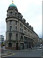
St Cuthbert's Building, Bread Street
Formerly the main Department Store of the St Cuthbert's Cooperative Association, this building occupies most of the south side of Bread Street.
Image: © kim traynor
Taken: 27 May 2009
0.03 miles
8

Edinburgh rooftops
A view across the tenements of Grindlay Street from the Point Hotel Conference Centre in Bread Street. The green copper dome of the Usher Hall and the wedding-cake-white of the Lyceum Theatre with its redbrick fly tower are clearly visible, with the spire of St. Cuthbert's at the West End behind them.
Image: © kim traynor
Taken: 23 Sep 2012
0.04 miles
9
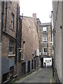
Grindlay Court Drill Hall gable
At the time of WW1 the home of 1 Lowland Brigade Royal Field Artillery (HQ, 1 & 2 Batteries and Ammunition Column) in a court behind 30 Grindlay Street. The gable on the left is part of the hall, and possible the nearer building too. http://www.geograph.org.uk/article/WW1-Great-War-Centenary---Drill-Halls/18#lothians. Since 1991 the building has been used by the Royal Lyceum Theatre Company, with the hall being used for rehearsals, and accessed at 30 Grindlay Street. Before the Lyceum it was used by Heriot-Watt University Students Union. A view looking out of the Court to Grindlay Street.
Image: © M J Richardson
Taken: 2 Jul 2014
0.04 miles
10

Bread Street Lane
Pends like the one above can be found all over central Edinburgh and are a reminder of the days of horse-drawn transport. Even this small alleyway cannot escape traffic signage and the ubiquitous yellow lines of modern parking restrictions.
Image: © kim traynor
Taken: 25 May 2009
0.04 miles