IMAGES TAKEN NEAR TO
Kings Cairn, Archerfield, NORTH BERWICK, EH39 5EX
Introduction
This page details the photographs taken nearby to Kings Cairn, Archerfield, EH39 5EX by members of the Geograph project.
The Geograph project started in 2005 with the aim of publishing, organising and preserving representative images for every square kilometre of Great Britain, Ireland and the Isle of Man.

There are currently over 7.5m images from over14,400 individuals and you can help contribute to the project by visiting https://www.geograph.org.uk
Image Map
Images are licensed for reuse under creativecommons.org/licenses/by-sa/2.0
Notes
- Clicking on the map will re-center to the selected point.
- The higher the marker number, the further away the image location is from the centre of the postcode.
Image Listing (46 Images Found)
Images are licensed for reuse under creativecommons.org/licenses/by-sa/2.0
Image
Details
Distance
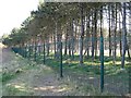
1
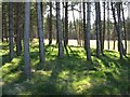
Plantation at Archerfield
Taken through 'the fence' - see Image
Image: © M J Richardson
Taken: 12 Apr 2009
0.02 miles
2
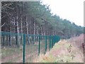
The green fence
An infamous eyesore, it could be supposed to be part of the defences of the rich only golf complex built in Archerfield woods. Apparently planning permission was given, as it will prevent access to remote beaches from the housing development associated with the golf. In other words it is to keep them in, rather than us out!
The attempt to close off the woods completely eventually fell foul of the law.
--
In the following years attitudes have changed completely and the estate has become very welcoming to visitors, and has even become a tourist attraction. Meanwhile houses have been built along the shoreline behind the fence.
Image: © Richard Webb
Taken: 6 Jan 2006
0.03 miles
3
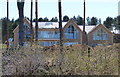
Large house under construction at Archerfield
Part of a luxury resort which includes the two golf courses of The Dirleton and The Fidra. This huge new luxury house is overlooking the beach at the Longskelly Rocks and the Firth of Forth.
Image: © Mat Fascione
Taken: 30 Apr 2018
0.04 miles
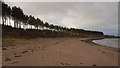
4
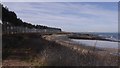
Coast opposite Fidra
A line of trees remain after the woodland behind them has been converted into bloated houses. How long will the trees remain now they are exposed?
Image: © Richard Webb
Taken: 20 Mar 2018
0.04 miles
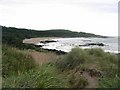
5
Beach west of Yellow Craig
The line of trees are survivors of the woods that once stood here before the golf course and houses.
Image: © Richard Webb
Taken: 25 Dec 2016
0.05 miles
6
The fence at Archerfield
Countryside Access, Scotland. In theory, a free for all, within reason, but we, on the other side of the fence, have very expensive houses and smart golf courses, so we would prefer you kept to your side of the fence. It is wearing well, three years on - see Image
Image: © M J Richardson
Taken: 12 Apr 2009
0.06 miles
7

New house at Archerfield
Not quite finished. Part of the large, exclusive development of houses on the Archerfield Estate, with golf courses, spa, lodges and other facilities.
Image: © M J Richardson
Taken: 23 Feb 2019
0.06 miles
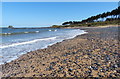
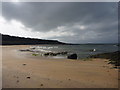
9
Bay West of Fidra.
Coast between Gullane Dunes and Yellow Craig.
Image: © Richard Webb
Taken: 8 Aug 2005
0.07 miles
10
Coastal East Lothian : Curved Sand
It's time to put some Mermen on the stereo and turn the volume up to 11 (one louder!).
Image: © Richard West
Taken: 1 Apr 2011
0.07 miles