
IMAGES TAKEN NEAR TO
Atholl Crescent, EDINBURGH, EH3 8HA
Introduction
This page details the photographs taken nearby to Atholl Crescent, EH3 8HA by members of the Geograph project.
The Geograph project started in 2005 with the aim of publishing, organising and preserving representative images for every square kilometre of Great Britain, Ireland and the Isle of Man.

There are currently over 7.5m images from over14,400 individuals and you can help contribute to the project by visiting https://www.geograph.org.uk
Image Map
Images are licensed for reuse under creativecommons.org/licenses/by-sa/2.0
Notes
- Clicking on the map will re-center to the selected point.
- The higher the marker number, the further away the image location is from the centre of the postcode.
Image Listing (841 Images Found)
Images are licensed for reuse under creativecommons.org/licenses/by-sa/2.0
Image
Details
Distance

2

Atholl Crescent Lane
Runs behind Atholl Crescent.
Image: © Thomas Nugent
Taken: 12 Aug 2012
0.02 miles
3
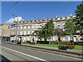
Atholl Crescent
Viewed from the West End tram stop. The crescent of houses dating from 1825 is listed category A (LB28260).
Image: © Stephen Craven
Taken: 30 Jun 2019
0.02 miles
4

Atholl Crescent Lane
Behind almost every imposing Georgian street in Edinburgh is a lane, built to provide stabling for horses and storage for carriages. The houses above the coach-houses are now desirable residences. The row on the left (south-east) side of Atholl Crescent Lane is Category C Listed. See https://portal.historicenvironment.scot/designation/LB46521.
Image: © Anne Burgess
Taken: 22 Mar 2023
0.02 miles

6

Atholl Crescent Lane
Behind almost every imposing Georgian street in Edinburgh is a lane, built to provide stabling for horses and storage for carriages. The houses above the coach-houses are now desirable residences. The row on the right (south-east) side of Atholl Crescent Lane is Category C Listed. See https://portal.historicenvironment.scot/designation/LB46521.
Image: © Anne Burgess
Taken: 22 Mar 2023
0.03 miles

8

Canning Street Lane
Between Canning Street and Atholl Crescent Lane.
Image: © Thomas Nugent
Taken: 12 Aug 2012
0.03 miles
9

Canning Street Lane
The former stables have become highly sought-after garages.
See link for the kind of car garaged here in the 1920s. http://www.edinphoto.org.uk/0_edin_t/0_edinburgh_transport_cars_vans_lorries_-_john_menzies_cars_chauffeur_standing.htm
Image: © kim traynor
Taken: 25 May 2009
0.03 miles
10

Edinburgh Trams Vehicle 952 Terminated at West End
The trams were operating only between Edinburgh Airport and West End due to engineering works. This shows Edinburgh Trams Unit 952 terminated at West End with a road barrier in situ to prevent it continuing. It is also unusual in that an Airport bound tram would not usually leave from this platform.
Image: © artful
Taken: 13 Feb 2023
0.04 miles