
IMAGES TAKEN NEAR TO
Mallard Walk, PRESTONPANS, EH32 9GD
Introduction
This page details the photographs taken nearby to Mallard Walk, EH32 9GD by members of the Geograph project.
The Geograph project started in 2005 with the aim of publishing, organising and preserving representative images for every square kilometre of Great Britain, Ireland and the Isle of Man.

There are currently over 7.5m images from over14,400 individuals and you can help contribute to the project by visiting https://www.geograph.org.uk
Image Map
Images are licensed for reuse under creativecommons.org/licenses/by-sa/2.0
Notes
- Clicking on the map will re-center to the selected point.
- The higher the marker number, the further away the image location is from the centre of the postcode.
Image Listing (57 Images Found)
Images are licensed for reuse under creativecommons.org/licenses/by-sa/2.0
Image
Details
Distance
1

New housing, Prestonpans
Big housing development on the southern edge of Prestonpans.
Image: © Richard Webb
Taken: 27 Mar 2007
0.03 miles
2

New houses, Prestonpans
On the south side of the B1361. The area between the road and railway is being infilled. There was building starting here in 2008 and it is continuing further west in 2020.
Image: © Richard Webb
Taken: 22 Jun 2020
0.06 miles

4

End of Preston Road
New houses beyond the B1361 (built 2008/09).
Image: © Richard Webb
Taken: 22 Jun 2020
0.08 miles


7

The Jim Bush Drive, Prestonpans.
Prestonpans the old coal town is expanding fast, to the north east and south west of the town. Also famous for salt panning. The town has produced many notable people but of the greatest 'Panners' of the modern era was Jim Bush. A local man, a proud Panner and Scot. He worked a lifetime in the coal pits. He was President and past Captain of the Royal Musselburgh Golf Club, a club he did so much to revive in the 1950s,and was President of the local Airts Club (Robert Burns Club) He was much sought after to recite Burns' work, of which, he was a renowned expert. He was very influential in the creating of The Burns Garden on the High Street. A very influential and sadly missed man. The street which bears his name is part of the new housing development near the golf course and stands off, what is known locally, as the top road - the main road to North Berwick.
Image: © James Denham
Taken: 26 May 2008
0.09 miles
8
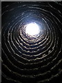
Northfield House Doocot, Prestonpans
Inside the 16th century beehive-shaped dovecot. The pigeons fly in through the opening. It contains approximately 600 stone nests and is still in use. It had been in a bad state of repair but was restored by the National Trust for Scotland.
Image: © Lisa Jarvis
Taken: 20 May 2006
0.10 miles
9

Angular houses, Prestonpans
High density housing with some very angular buildings.
Image: © Richard Webb
Taken: 5 Aug 2005
0.10 miles
