
IMAGES TAKEN NEAR TO
Bavelaw Crescent, PENICUIK, EH26 9AU
Introduction
This page details the photographs taken nearby to Bavelaw Crescent, EH26 9AU by members of the Geograph project.
The Geograph project started in 2005 with the aim of publishing, organising and preserving representative images for every square kilometre of Great Britain, Ireland and the Isle of Man.

There are currently over 7.5m images from over14,400 individuals and you can help contribute to the project by visiting https://www.geograph.org.uk
Image Map
Images are licensed for reuse under creativecommons.org/licenses/by-sa/2.0
Notes
- Clicking on the map will re-center to the selected point.
- The higher the marker number, the further away the image location is from the centre of the postcode.
Image Listing (14 Images Found)
Images are licensed for reuse under creativecommons.org/licenses/by-sa/2.0
Image
Details
Distance
1

Looking down on Penicuik from Turnhouse Hill
Image: © Anthony O'Neil
Taken: 21 Aug 2011
0.05 miles
2

Shopping Centre without shops
This planners dream of a small shopping centre in the middle of the Cornbank housing estate in Penicuik never really prospered and no longer contains any retail outlets. The provision of a convenient bus service to and from the larger supermarkets in the town will have rendered any possible shops on this site even less viable.
Image: © Morley Sewell
Taken: 8 Jun 2009
0.05 miles
3
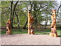
Woodland creatures
These sculptures have recently appeared in the wood beside Cornbank Primary School.
Image: © Mike Bremner
Taken: 22 May 2012
0.07 miles
4

Cornbank
A tidy 1960's housing estate to the west of Penicuik.(NT227603)
Image: © Richard Webb
Taken: 3 May 2005
0.15 miles
5

Rullion Road, Penicuik
A feeder road around this large estate on the NW edge of Penicuik.
Image: © M J Richardson
Taken: 28 Mar 2009
0.16 miles
6

Footbridge, Cuiken Burn
On the path up the Cuiken Glen from Penicuik, with houses at Brunstane Gardens beyond.
Image: © Jim Barton
Taken: 28 Feb 2012
0.18 miles
7

Footpath at Rullion Road, Penicuik
The sign denotes Lowrie's Den circuit and Cuiken Glen circuit. The red bin is for bags of dog waste, but it's best to keep an eye on where one is treading in these easily accessible paths as some dog owners prefer to provide a grass manuring service.
Image: © Jim Barton
Taken: 28 Feb 2012
0.19 miles
8

Looking towards the Pentlands
Cuiken Burn, coming down from Rullion Road, provides one of many green spaces in this large area of houses.
Image: © M J Richardson
Taken: 28 Mar 2009
0.20 miles
9

The Cuiken Burn is in there somewhere!
Just downstream from Rullion Road.
Image: © M J Richardson
Taken: 28 Mar 2009
0.20 miles
10

The Cuiken Burn at Penicuik
Looking downstream from Rullion Road.
Image: © M J Richardson
Taken: 28 Mar 2009
0.21 miles