
IMAGES TAKEN NEAR TO
Waulkmill Drive, PENICUIK, EH26 8LA
Introduction
This page details the photographs taken nearby to Waulkmill Drive, EH26 8LA by members of the Geograph project.
The Geograph project started in 2005 with the aim of publishing, organising and preserving representative images for every square kilometre of Great Britain, Ireland and the Isle of Man.

There are currently over 7.5m images from over14,400 individuals and you can help contribute to the project by visiting https://www.geograph.org.uk
Image Map
Images are licensed for reuse under creativecommons.org/licenses/by-sa/2.0
Notes
- Clicking on the map will re-center to the selected point.
- The higher the marker number, the further away the image location is from the centre of the postcode.
Image Listing (60 Images Found)
Images are licensed for reuse under creativecommons.org/licenses/by-sa/2.0
Image
Details
Distance
1

Path and cycleway approaching Valleyfield, Penicuik
The old Penicuik railway now makes an excellent path and cycleway following the North Esk, here not far from its destination at Valleyfield.
Image: © Jim Barton
Taken: 15 Dec 2011
0.07 miles
2

Old mill lade, Penicuik
Now choked with weeds and branches, the lade is a reminder of the days when water-powered mills operated along this stretch of the River North Esk.
Image: © Jim Barton
Taken: 20 May 2022
0.07 miles
3

Don't fall in...
Taken from the slippery bank at great risk by your photographer, showing the old mill lade that supplied Eskmill paper mill from the River North Esk upstream.
The 6" OS map of 1905 (Edinburghshire sheet XIII.NE) shows that this area including Valleyfield Mill upstream was once a large industrial complex with its own railway network. Now the mill sites at Valleyfield, Eskbridge and Dalmore have become housing areas, almost small villages in their own right.
Image: © Jim Barton
Taken: 19 Sep 2016
0.08 miles
4

Penicuik Railway trackbed
South of the site of Esk Mills.
Image: © Richard Webb
Taken: 19 Apr 2016
0.09 miles
5

The Legion club, Penicuik
On Kirkhill Road, near the Eskhill residential area.
Image: © Jim Barton
Taken: 3 Jun 2026
0.10 miles
6

Houses on Kirkhill Road, Penicuik
Cottage-style houses on Kirkhill Road where it descends towards the River South Esk.
Image: © Jim Barton
Taken: 19 Sep 2016
0.10 miles
7
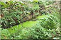
Old mill lade near the North Esk, Penicuik
This part of the mill lade has a section of brick retaining wall. The lade is between the cyclepath (on the former railway to Valleyfield Mill) and the pedestrian path by the river.
The 6" OS map of 1905 (Edinburghshire sheet XIII.NE) shows that this area including Valleyfield Mill upstream was once a large industrial complex with its own railway network. Now the mill sites at Valleyfield, Eskbridge and Dalmore have become housing areas, almost small villages in their own right.
Image: © Jim Barton
Taken: 19 Sep 2016
0.11 miles
8

Kirkhill Brae
Penicuik is deceptively hilly once you get away from the town centre.
Image: © Anne Burgess
Taken: 25 Feb 2018
0.12 miles
9

Paths by the North Esk, Valleyfield
The path and cycleway on the old Penicuik railway line has almost reached the terminus at Valleyfield, site of the old Penicuik station - see http://www.disused-stations.org.uk/p/penicuik/index.shtml for much more detail of its history.
The path to the right keeps closer to the North Esk, rejoining the railway route near the new housing development at Eskmill.
Image: © Jim Barton
Taken: 15 Dec 2011
0.12 miles
10

Penicuik - the Papermaking Town
An information board at Eskmill on the route of the Dalkeith - Penicuik cycleway and footpath. Industrial papermaking started in Penicuik in 1779 at the Valleyfield Mill, which closed in 1974 while the Dalmore papermill at nearby Auchendinny continued to 2004.
Image: © Jim Barton
Taken: 15 Dec 2011
0.12 miles