
IMAGES TAKEN NEAR TO
GOREBRIDGE, EH23 4SA
Introduction
This page details the photographs taken nearby to EH23 4SA by members of the Geograph project.
The Geograph project started in 2005 with the aim of publishing, organising and preserving representative images for every square kilometre of Great Britain, Ireland and the Isle of Man.

There are currently over 7.5m images from over14,400 individuals and you can help contribute to the project by visiting https://www.geograph.org.uk
Image Map
Images are licensed for reuse under creativecommons.org/licenses/by-sa/2.0
Notes
- Clicking on the map will re-center to the selected point.
- The higher the marker number, the further away the image location is from the centre of the postcode.
Image Listing (21 Images Found)
Images are licensed for reuse under creativecommons.org/licenses/by-sa/2.0
Image
Details
Distance
1

Ordnance Survey Flush Bracket 10442
This can be found on the wall of a cottage near Esperton.
For more detail see : http://www.bench-marks.org.uk/bm20551
Image: © Peter Wood
Taken: 6 Oct 2016
0.01 miles
2

Road and cottages near Esperton
Looking north-eastward.
Image: © Peter Wood
Taken: 6 Oct 2016
0.02 miles
3

Ash wood, Halkerston Glen
Limestone country.
Image: © Richard Webb
Taken: 2 Apr 2021
0.03 miles
4
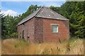
Former engine shed, Esperston Lime Works
The building is shown on the OS 6" sheet Edinburghshire XIV.SE (1908) as an engine shed for the Lime Works Railway connecting with the North British line at Catcune. The map also shows a tramway running southwards into the workings for about half a kilometre.
Image: © Jim Barton
Taken: 27 Jul 2018
0.04 miles
5

Approach to former Esperston Lime Works
An area of old limestone quarries and associated buildings by the minor road west of Middleton. The building on the left is shown on the OS 6" sheet Edinburghshire XIV.SE (1908) as an engine shed for the Lime Works Railway connecting with the North British line at Catcune.
Image: © Jim Barton
Taken: 27 Jul 2018
0.04 miles
6

Old limestone quarry near Esperston (2)
The NW side of the old quarry workings seen from the Middleton road.
Image: © Jim Barton
Taken: 1 Dec 2014
0.08 miles
7

Former railway sidings, Esperston Lime Works
An area of old limestone quarries and associated buildings by the minor road west of Middleton, shown on the OS 6" sheet Edinburghshire XIV.SE (1908). The Lime Works Railway connected the workings here with the North British line at Catcune.
Image: © Jim Barton
Taken: 27 Jul 2018
0.08 miles
8

Old limestone quarry near Esperston
Unlike the nearby Temple Quarry (sand and gravel), this used to be a limestone quarry, with the same outcrop continuing a short way NW to the current Middleton Quarry and lime works. There is a limestone outcrop by the road, out of shot to the left. The road here crosses the Middleton North Burn.
Although now predominantly a farming area, coal mining on a small scale once took place at Temple on the banks of the South Esk. For example, see Image
Image: © Jim Barton
Taken: 1 Dec 2014
0.11 miles
9

Bridge over Middleton North Burn
The minor road from Middleton crosses the burn near the old quarries and lime works with Halkerston Glen in the background.
Image: © Jim Barton
Taken: 27 Jul 2018
0.11 miles
10

Bridge carrying aroad over Middleton North Burn near Esperton
Looking eastward.
Image: © Peter Wood
Taken: 6 Oct 2016
0.12 miles