
IMAGES TAKEN NEAR TO
DALKEITH, EH22 1RU
Introduction
This page details the photographs taken nearby to EH22 1RU by members of the Geograph project.
The Geograph project started in 2005 with the aim of publishing, organising and preserving representative images for every square kilometre of Great Britain, Ireland and the Isle of Man.

There are currently over 7.5m images from over14,400 individuals and you can help contribute to the project by visiting https://www.geograph.org.uk
Image Map
Images are licensed for reuse under creativecommons.org/licenses/by-sa/2.0
Notes
- Clicking on the map will re-center to the selected point.
- The higher the marker number, the further away the image location is from the centre of the postcode.
Image Listing (62 Images Found)
Images are licensed for reuse under creativecommons.org/licenses/by-sa/2.0
Image
Details
Distance
1

Sheriffhall Doocot
This doocot was built from red sandstone and basalt in the early 17th century. It was created from the stair tower of the former Sheriffhall mansion that was demolished. It originally had a number of arched windows but these have been filled in (presumably on conversion to doocot). It has a pyramidal slated roof, with lantern entrance for the pigeons. Inside there are 850 wooden nesting boxes.
Image: © Lisa Jarvis
Taken: 25 May 2007
0.02 miles
2

Sheriffhall Doocot
An early 17 Century doocot that was originally a tower house.
Image: © M J Richardson
Taken: 6 Nov 2008
0.04 miles
3

Track to Sheriffhall Farm
Off Old Dalkeith Road (A6106).
Image: © JThomas
Taken: 15 May 2015
0.05 miles
4

Old Dalkeith Road (A6106)
Heading south east.
Image: © JThomas
Taken: 15 May 2015
0.07 miles
5

The Borders Railway at Sheriffhall
Looking down on the course of the newline between its crossing under the A720 and A6106.
Image: © M J Richardson
Taken: 18 Sep 2013
0.07 miles
6

Approaching the Sheriffhall roundabout
Image: © Alpin Stewart
Taken: 28 Apr 2019
0.08 miles
7

Autumn birches on the Waverley Line at Sheriffhall
The route of the line is now part of the Penicuik to Musselburgh Foot and Cycleway.
Image: © M J Richardson
Taken: 6 Nov 2008
0.09 miles
8
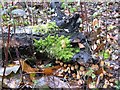
Ink caps and candlesnuff fungi
Both are growing on a dead and fallen birch. The buff ink cap toadstools are Coprinus micaceus. The candle snuff fungi [Xylaria hypoxylon] are the black bits with white tips on the top of the log. Both contribute to the decay and recycling of the dead birch, but are not responsible for its death.
Image: © M J Richardson
Taken: 6 Nov 2008
0.09 miles
9
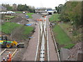
Borders Railway at Sheriffhall
The railway passes under the Edinburgh by-pass [A720], and the double track becomes a single track, which will continue for most of the route, apart from passing places. For a view one year ago see Image
Image: © M J Richardson
Taken: 10 Oct 2014
0.10 miles
10

The Borders Railway at Sheriffhall
Progress since September 2013 Image The road bridge over the line of the railway is in place, and the diversion has been removed. Gabions to retain the embankment of the Melville Gate bridge are being placed.
Image: © M J Richardson
Taken: 8 Jul 2014
0.10 miles