
IMAGES TAKEN NEAR TO
Elmfield Court, DALKEITH, EH22 1DY
Introduction
This page details the photographs taken nearby to Elmfield Court, EH22 1DY by members of the Geograph project.
The Geograph project started in 2005 with the aim of publishing, organising and preserving representative images for every square kilometre of Great Britain, Ireland and the Isle of Man.

There are currently over 7.5m images from over14,400 individuals and you can help contribute to the project by visiting https://www.geograph.org.uk
Image Map
Images are licensed for reuse under creativecommons.org/licenses/by-sa/2.0
Notes
- Clicking on the map will re-center to the selected point.
- The higher the marker number, the further away the image location is from the centre of the postcode.
Image Listing (119 Images Found)
Images are licensed for reuse under creativecommons.org/licenses/by-sa/2.0
Image
Details
Distance
1

Archview Lodge Nursing Home
Just to the south of Newmills Road (the A6106).
Image: © Barbara Carr
Taken: 2 Jul 2013
0.07 miles
2

Peacocks, Dalkeith
At the time the shop chain was in administration. It was bought by Edinburgh Woollen Mills and the fate of this store is currently unknown.
Image: © Richard Webb
Taken: 17 Jan 2012
0.08 miles

4

Co-Op Clock Tower
The Flemish-style clock tower tops what used to be the Co-Operative Society building, dating from 1887 and designed by J W Maclean, probably James White Maclean, who was born in Dalkeith in 1861.
Image: © Anne Burgess
Taken: 10 Oct 2018
0.09 miles
5

Newmills Road, Dalkeith
Looking down Newmills Road from South Street.
Image: © Richard Webb
Taken: 15 Oct 2015
0.09 miles
6

Former Inn
'The Buildings of Scotland' mentions the twin-gabled 18th century Old Meal Market Inn, and the first 25-inch maps marks this as an inn, so I deduce that what was the inn is now the premises of William Hill. Sic transit gloria mundi.
Image: © Anne Burgess
Taken: 10 Oct 2018
0.09 miles
7

The Blacksmith's Forge
The Blacksmith's Forge, a J D Wetherspoon pub and restaurant.
Image: © Colin Kinnear
Taken: 19 Mar 2017
0.11 miles
8
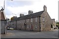
London Road, Dalkeith
Crossroads between Buccleuch Street, London Road(left), Lothian Street (behind the camera) and Lothian Road(right).
Image: © Richard Webb
Taken: 15 Oct 2015
0.11 miles
9
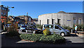
Taxi Rank
The taxi rank in Dalkeith town centre is tucked away where it doesn't impinge on the townscape or get in the way of traffic. It's not as if you expect strangers to need to know where to find a taxi, is it? The round building is part of the council offices, and looks as if it has been boarded up.
Image: © Anne Burgess
Taken: 10 Oct 2018
0.11 miles
10

Eskdail Court
Back of flats in Dalkeith town centre.
Image: © Richard Webb
Taken: 9 Sep 2019
0.11 miles