
IMAGES TAKEN NEAR TO
Benhar Road, MUSSELBURGH, EH21 8RR
Introduction
This page details the photographs taken nearby to Benhar Road, EH21 8RR by members of the Geograph project.
The Geograph project started in 2005 with the aim of publishing, organising and preserving representative images for every square kilometre of Great Britain, Ireland and the Isle of Man.

There are currently over 7.5m images from over14,400 individuals and you can help contribute to the project by visiting https://www.geograph.org.uk
Image Map
Images are licensed for reuse under creativecommons.org/licenses/by-sa/2.0
Notes
- Clicking on the map will re-center to the selected point.
- The higher the marker number, the further away the image location is from the centre of the postcode.
Image Listing (139 Images Found)
Images are licensed for reuse under creativecommons.org/licenses/by-sa/2.0
Image
Details
Distance
1

Building site, Newcraighall
Ground work, presumably for house building.
Image: © Richard Webb
Taken: 4 Jul 2014
0.02 miles
2

Railway footbridge
Dilapidated footbridge that has somehow survived the dismantling of this section of railway line (one of several dismantled lines in the vicinity).
The bridge serves no purpose today other than as a viewpoint and presumably as a place for children to play.
Image: © Callum Black
Taken: 1 Mar 2008
0.04 miles
3
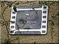
Plaque for Bill Douglas, Film Director
Bill Douglas [1934-1991] was born in the mining village of Newcraighall. His professional work retraced events of his own childhood and early adult life, as The Trilogy, comprising My Childhood (1972), My Ain Folk (1973) and My Way Home (1978) which won many international awards. His next project, the epic Comrades, took eight years to realise, finally emerging in 1987 as a three-hour account of the nineteenth-century trade union pioneers the Tolpuddle Martyrs
Image: © M J Richardson
Taken: 18 Feb 2009
0.04 miles


7

Cycle path, Newcraighall
A surfaced road on a railway trackbed.
Image: © Richard Webb
Taken: 4 Jul 2014
0.05 miles
8

Rails to trails, Newcraighall
One of the lines that served the coalfield, now a bike path.
Image: © Richard Webb
Taken: 20 Jan 2022
0.06 miles
9

Old railway, Wanton Walls
Part of the National Cycle Network and in the heart of rapid urbanisation. The railway was a relief line built to take coal traffic away from the busy East Coast Main Line.
Image: © Richard Webb
Taken: 27 Mar 2021
0.06 miles
10

Newcraighall: Former church
This former Church of Scotland building is now used for child care.
Image: © Dr Neil Clifton
Taken: 12 Sep 2014
0.06 miles