
IMAGES TAKEN NEAR TO
Whitecraig Avenue, MUSSELBURGH, EH21 8PB
Introduction
This page details the photographs taken nearby to Whitecraig Avenue, EH21 8PB by members of the Geograph project.
The Geograph project started in 2005 with the aim of publishing, organising and preserving representative images for every square kilometre of Great Britain, Ireland and the Isle of Man.

There are currently over 7.5m images from over14,400 individuals and you can help contribute to the project by visiting https://www.geograph.org.uk
Image Map
Images are licensed for reuse under creativecommons.org/licenses/by-sa/2.0
Notes
- Clicking on the map will re-center to the selected point.
- The higher the marker number, the further away the image location is from the centre of the postcode.
Image Listing (17 Images Found)
Images are licensed for reuse under creativecommons.org/licenses/by-sa/2.0
Image
Details
Distance
1

Deantown Bowling Club
In Whitecraig, East Lothian.
Image: © James Denham
Taken: 16 Aug 2013
0.01 miles
2

Whitecraig railway path
Served collieries in East Lothian and Midlothian. It was a double track line here.
Image: © Richard Webb
Taken: 28 May 2020
0.06 miles
3

Path, Whitecraig
A path leads under the old railway to the A6124 by Carberry.
Image: © Richard Webb
Taken: 19 Nov 2017
0.08 miles
4

Whitecraig Avenue
A cul-de-sac of houses at the end of Whitecraig Avenue.
Image: © Anne Burgess
Taken: 8 Jan 2018
0.12 miles

6

Farmland east of Whitecraig
Fields north of Carberry Mains seen from the cyclepath.
Image: © Jim Barton
Taken: 17 Jul 2018
0.19 miles
7

Gardens and paths on the village green
At Whitecraig, East Lothian.
Image: © James Denham
Taken: 16 Aug 2013
0.19 miles
8
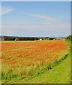
Field of Poppies
From the bridge over the old railway line - now a cycle path - the contrasting colours of the red poppies, green grass, blue sky and even the yellow of the fencing at the building site caught my eye - almost like an impressionist painting.
Image: © Adam Ward
Taken: 2 Jul 2011
0.20 miles
9

Macmerry Branch, Whitecraig
Now used by the National Cycle Network.
Image: © Richard Webb
Taken: 19 Nov 2017
0.20 miles
10

Burn, Carberry
A burn deepened for land drainage in a wettish area.
Image: © Richard Webb
Taken: 2 Jan 2016
0.21 miles