
IMAGES TAKEN NEAR TO
Craigour Crescent, EDINBURGH, EH17 7NS
Introduction
This page details the photographs taken nearby to Craigour Crescent, EH17 7NS by members of the Geograph project.
The Geograph project started in 2005 with the aim of publishing, organising and preserving representative images for every square kilometre of Great Britain, Ireland and the Isle of Man.

There are currently over 7.5m images from over14,400 individuals and you can help contribute to the project by visiting https://www.geograph.org.uk
Image Map
Images are licensed for reuse under creativecommons.org/licenses/by-sa/2.0
Notes
- Clicking on the map will re-center to the selected point.
- The higher the marker number, the further away the image location is from the centre of the postcode.
Image Listing (46 Images Found)
Images are licensed for reuse under creativecommons.org/licenses/by-sa/2.0
Image
Details
Distance


3

Moredun high rise flats
Nearest block is Moredun House and furthest away is Castleview House. To the left Craigmillar Castle can just be seen.
Image: © Kay Williams
Taken: 17 Oct 2009
0.12 miles
4

High rise, Moredun
Tower blocks on Craigour Green, seen from the Pentland Hills. Cockenzie power station and ash bings dominate the coastal view beyond. There is some construction work in progress by the Royal Edinburgh Infirmary.
Image: © Richard Webb
Taken: 28 Nov 2010
0.12 miles
5

New and old housing at Moredun
There are six multi-storey blocks at Moredun - these four are in a row (from left: Castleview House, Little France House, Mary Tree House, Moredun House). Newer more convential terraced housing has been built alongside. The playing field in the foreground belongs to Goodtrees Neighbourhood Centre (confusingly labelled school on the OS map).
Image: © Kay Williams
Taken: 17 Oct 2009
0.12 miles
6

High-rise Flats
These are four of the six fifteen-storey blocks of flats at Moredun. The nearer pair are Craigour Green and the further pair are Craigour Place.
Image: © Anne Burgess
Taken: 1 Mar 2017
0.13 miles
8

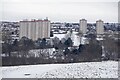
High rises at Craigour
A set of four 1960s high rise blocks, seen from Edinburgh's Bioquarter.
Image: © M J Richardson
Taken: 13 Mar 2014
0.13 miles
9

Craigour Grove
Junction with Craigour Crescent.
Image: © Richard Webb
Taken: 28 Feb 2024
0.13 miles
10

Upper Craigour
Almost all of this square is occupied by the Royal Infirmary, but this little corner is made up of low-rise housing with absolutely no parking at all except for residents. This, presumably, is to prevent it being overrun with people going to the Infirmary.
Image: © Anne Burgess
Taken: 1 Mar 2017
0.14 miles