
IMAGES TAKEN NEAR TO
Nether Currie Road, CURRIE, EH14 5JD
Introduction
This page details the photographs taken nearby to Nether Currie Road, EH14 5JD by members of the Geograph project.
The Geograph project started in 2005 with the aim of publishing, organising and preserving representative images for every square kilometre of Great Britain, Ireland and the Isle of Man.

There are currently over 7.5m images from over14,400 individuals and you can help contribute to the project by visiting https://www.geograph.org.uk
Image Map
Images are licensed for reuse under creativecommons.org/licenses/by-sa/2.0
Notes
- Clicking on the map will re-center to the selected point.
- The higher the marker number, the further away the image location is from the centre of the postcode.
Image Listing (9 Images Found)
Images are licensed for reuse under creativecommons.org/licenses/by-sa/2.0
Image
Details
Distance
1

Muir Wood Road, Currie
The sign points the way to traffic-free route from Currie to the Heriot-Watt campus.
Image: © michael ely
Taken: 21 Feb 2011
0.05 miles
2

Bridleway to Heriot-Watt University
This lane forms a traffic-free link to the university's campus from the edge of Currie.
Image: © michael ely
Taken: 21 Feb 2011
0.12 miles
3
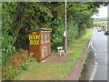
The Book Box, Muirwood Road, Currie
A very smart 'little free library' at the edge of a 1960's estate in Currie, complete with a seat for browsing.
Image: © M J Richardson
Taken: 15 Aug 2023
0.14 miles
4
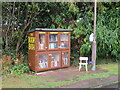
The Book Box, Muirwood Road, Currie
A very smart 'little free library' at the edge of a 1960's estate in Currie, complete with a seat for browsing.
Image: © M J Richardson
Taken: 15 Aug 2023
0.14 miles
5

Test centre, Currie
A nerve jangling sight in Currie. The square is divided between rather homgenous housing, as in NT1768 and NT1767 and a heavily fortified golfcourse.
Image: © Richard Webb
Taken: 4 Aug 2005
0.18 miles


8

Frosty path at Baberton
Footpath from Currie towards Whitelaw and the Hermiston Park & Ride area of the A71 Calder Road.
Image: © M J Richardson
Taken: 1 Dec 2008
0.22 miles
9

Water of Leith Currie Edinburgh
Water of Leith as it runs through the east side of Currie Edinburgh in 2007
Image: © stephen samson
Taken: 8 Sep 2007
0.25 miles