
IMAGES TAKEN NEAR TO
Burnbrae, EDINBURGH, EH12 8UB
Introduction
This page details the photographs taken nearby to Burnbrae, EH12 8UB by members of the Geograph project.
The Geograph project started in 2005 with the aim of publishing, organising and preserving representative images for every square kilometre of Great Britain, Ireland and the Isle of Man.

There are currently over 7.5m images from over14,400 individuals and you can help contribute to the project by visiting https://www.geograph.org.uk
Image Map
Images are licensed for reuse under creativecommons.org/licenses/by-sa/2.0
Notes
- Clicking on the map will re-center to the selected point.
- The higher the marker number, the further away the image location is from the centre of the postcode.
Image Listing (35 Images Found)
Images are licensed for reuse under creativecommons.org/licenses/by-sa/2.0
Image
Details
Distance
1
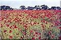
East Craigs poppies
East Craigs, at the time this photo was taken, was not a housing estate, but the laboratories and experimental farm of what is now the Scottish Agricultural Science Agency Image The year before, it had been decided that the land would be sold for housing, so was not cultivated over the winter. The resulting mass of poppies was spectacular, originating from a dormant seed bank in the soil, despite the fact that weed control in the fields, used for experimental plots and crops, had been practised for many years
Image: © M J Richardson
Taken: Unknown
0.05 miles
2

Poppies
Detail of the poppies in the field at East Craigs Image
Image: © M J Richardson
Taken: Unknown
0.08 miles
3
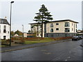
New houses at East Craigs
One block on Burnbrae Drive, part of a large residential development on the site of what was government agricultural and plant health laboratories and plant breeding station. Under various names they had been there since 1925. The farmland was rezoned for housing and new laboratories were built and occupied at Gogarbank in 2006 Image The East Craigs laboratories were demolished and replaced with houses. The house to the left is East Craigs House- see Image
Image: © M J Richardson
Taken: 11 Nov 2012
0.10 miles


6

New Housing at Burnbrae
Some of the new housing developments on the west side of Edinburgh.
Image: © Anne Burgess
Taken: 26 Sep 2021
0.12 miles
7
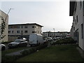
Burnbrae Drive at East Craigs
Part of a large residential development on the site of what was government agricultural and plant health laboratories and plant breeding station. Under various names they had been there since 1925. The farmland was rezoned for housing and new laboratories were built and occupied at Gogarbank in 2006 Image The East Craigs laboratories were demolished and replaced with houses.
Image: © M J Richardson
Taken: 11 Nov 2012
0.12 miles
8

East Craigs House
The house on Burnbrae Drive, fitting into the landscape four years or so after its restoration Image
Image: © M J Richardson
Taken: 22 Jun 2016
0.13 miles
9
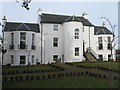
East Craigs House
On Burnbrae Drive, a newly restored house originally built in 1768, with an octagonal staircase added c. 1800. The restoration is part of a large residential development on the site of what was government agricultural and plant health laboratories and plant breeding station. Under various names they had been there since 1925. The farmland was rezoned for housing and new laboratories were built and occupied at Gogarbank in 2006 Image The East Craigs laboratories were demolished and replaced with houses; East Craigs House was last used as a residence in the 1950/60s, when it was the home of William Robb, the last director of the Scottish Society for Plant Breeding Research Station before it moved to Pentlandfield. A picture of the house in 1921 can be seen at http://www.scri.ac.uk/scri/file/annualreports/SCRI_History_AnnualReport2010.pdf [p. 3, and a portrait of William Robb on p.16]. From the outside the restoration looks very good.
Image: © M J Richardson
Taken: 11 Nov 2012
0.13 miles
10

4a, 4b and 4c Burnbrae Drive
Category C Listed building with later additions, including the semi-octagonal tower at the front. See http://portal.historicenvironment.scot/designation/LB28069 for more information.
Image: © Anne Burgess
Taken: 26 Sep 2021
0.13 miles